Improved resolution three-dimensional integral
- 格式:pdf
- 大小:496.52 KB
- 文档页数:7
磁共振水成像技术对内耳的成像研究及应用研究生:明洁导师:贾文霄教授摘要目的:探讨磁共振水成像技术(Magnetic resonance hydrography MRH)的三种后处理方法,即多平面重建(MPR)、最大密度投影(MIP)、容积再现(VR)对内耳显示分别有各自优势,为不同内耳原因导致的感音神经性耳聋(SNHL)选择简单、合理、有效的扫描序列和最佳后处理方法,为临床无创评估内耳病变及诊断治疗提供客观有效的影像学依据。
方法:对80例无听力障碍的正常人及45例临床确诊为SNHL的患者行高分辨率三维快速自旋回波T2加权序列(3D TSE T2WI)行横断面扫描,然后行3D TSE T2WI双侧斜矢状面扫描。
对45例SNHL患者加扫T1WI,若该序列显示有异常信号则行T1WI扫描。
数据采集后传至工作站利用ViewForum后处理软件行MPR、MIP、VR 重建。
观察正常内耳及内听道解剖结构的显示情况,并进行测量。
应用统计学方法对测量值及不同后处理技术对内耳各解剖结构评分,分别行组间及不同后处理方法间的差异性检验。
结果:(1)正常志愿者组80例160耳均能清晰地显示耳蜗前庭神经、面神经、蜗神经及内耳膜迷路的细微解剖结构。
(2)VR、MIP测量前、水平、后半规管最大径及管径,蜗管管径及最大径差异有统计学意义;VR、MIP图像质量的差异有统计学意义;VR、MIP、MPR显示膜迷路诸结构及神经的能力的差异具有统计学意义;(3)45例病人中MRI内耳发现有9例异常(阳性率20%),共7种病变,其中儿童(小于14岁)以先天性异常-前庭导水管扩大(3例)最常见。
结论:(1)内听道及膜迷路的细微结构可利用磁共振内耳水成像技术得以立体而直观的显示,具有其他方法不可替代的作用;(2)MRH对SNHL病因的诊断有很好的指导作用,是有效的影像学检查方法;(3)在多种内耳水成像技术的后处理方法中,MPR在显示神经方面具有优势,VR在观察膜迷路形态方面更具优势,其图像更清晰,与周围结构的毗邻关系显示的更加确切,能对内耳形态是否具有改变进行更有效地评估。
物探专业术语1、观测系统测线上激发点和接收点的相对位置关系。
为了得到能够系统地追踪目的层有效波的地震记录,在野外资料采集时必须适当地安排和选择激发点与接收点的相互位置,即要选择合理的观测系统。
2、二维地震勘探沿着地表的一条直线进行勘测,就能够研究该测线下面不同地层界面的形状和位置,这种勘测方法称为二维地震勘探,相应的观测系统称为2D观测系统。
3、三维地震勘探如果在地表的某一平面内连续地进行观测,就能够最佳地研究该平面下不同地震界面的形状和位置,这种勘测方法称为三维地震勘探,相应的观测系统称为3D观测系统。
4、多次覆盖对界面上某一点进行观测称为采样或覆盖。
若对每个点只观测一次,称为单次覆盖,如观测多次,则称为多次覆盖。
5、覆盖次数对界面上某一点进行观测的次数。
覆盖次数的设计:假如目的层反射波能量强,连续性好,能够可靠地追踪,那么每个反射点只需要勘测一次就足够了。
但是实际情况并非如此,有效反射波总是与各种干扰波重叠干涉。
当勘探深度增大时,由于多次波和散射波相对加强,信噪比变得更低,单次覆盖效果不佳,因此现在广泛采用多次覆盖系统。
基本思路:用一组单次覆盖系统,其中每一种都可以沿侧线连续追踪同一反射界面,当资料处理合适时,反射层应该位于每个地震剖面的相同地段。
6、炸药震源炸药震源是脉冲震源。
炸药在外界的影响下迅速放出气体和高热,形成高压气团而急剧膨胀,在很短的瞬间将冲击力作用于周围物体,即形成所谓的冲击波。
在爆炸中心,物体被粉碎、破坏或产生非弹性形变。
在破坏带及非弹性形变带外,形成岩石的弹性变带,此时冲击波变成弹性波传播出去。
常用的炸药是硝氨炸药。
经验表明,炸药激发的地震振动是衰减很快的似正弦脉冲,脉冲的前缘很陡,能量高度集中。
在均匀介质中爆炸时形成中心对称的膨胀型震源,主要产生纵波。
7、可控震源这是50年代问世的一种新型震源,因为它产生一个延续时间从几秒到几十秒,频率随时间变化的正弦振动,故称为连续振动震源;又因为扫描的频率范围及振动的延续长度都可以事先控制和改变,故称可控震源。
精品文档Glossary of《Introduction to Modern Photogrammetry》《当代摄影测量》双语教学词汇表AAbbe comparator principle阿贝比长原理aberration 像差absolute flying height 绝对航高absolute orientation 绝对定向absorption 吸收access 存取、访问accessory 附件、辅助设备accident error 偶然误差accuracy 精度、准确度accuracy assessment 精度评定acquisition 获取active remote sensing 主动式遥感adaptability 适应性adjustment 平差adjacent 邻接adjacent flight line 相邻航线adjacent area 邻接区域adjoining sheets 邻接图幅aerial camera 航空摄影机aerial photograph 航摄像片aerial photographic gap 航摄漏洞aerial photogrammetry航空摄影测量aerial remote sensing 航空遥感aerophotogrammetry 航空摄影测量aerotriangulation 空中三角测量block triangulation区域网三角测量strip triangulation航带法空中三角测量independent model triangulation独立模型法空中三角测量bundle triangulation光束法空中三角测量affine rectification 仿射纠正affined transformation 仿射变换aggregation 聚合、聚集air base 摄影基线airbone imagery 机载影像airborne sensor 机载传感器alignment 排列成行、对准algebra 代数algorithm 算法allocation 配置altimeter 测高仪altitude 高度、高程ambiguity 模糊、不定性anaglyph 互补色anaglyphical stereoscopic viewing互补色立体观察analog 模拟analog/digital conversion 模数转换analog photogrammetry 模拟摄影测量analytical aerotriangulation解析空中三角测量analytical photogrammetry 解析摄影测量analytical plotter 解析测图仪ancillary data 辅助数据angular field of view 像场角angular momentum 角动量animation 动画annotation 注释、注记annotated photograph 调绘像片aperture 光圈、孔径relative ~ 相对孔径effective ~ 有效孔径approximation 近似值、逼近archive 档案archiving 存档architectural photogrammetry建筑摄影测量archaeological photogrammetry考古摄影测量artificial intelligence 人工智能artificial target 人工标志(点)aspect 方位aspect map 坡向图assessment 评定、估价astigmatism 像散atlas 地图集atmospheric haze 大气蒙雾atmospheric refraction 大气折光atmospheric window 大气窗口atmospheric transmission 大气传输atmospheric transmissivity 大气透过率attenuation 衰减attitude 姿态attitude parameter 姿态参数attribute 属性autocollimation 自准直autocorrelation 自相关automatic triangulation自动空中三角测量azimuth angle 方位角azimuth resolution 方位角分辨率Bbackprojection 逆投影backup 备份ballistic camera 弹道摄影机ballistic photogrammetry弹道摄影测量bandwidth 波段宽barrel 圆筒、桶形失真baseline 基线base-height ratio 基-高比batch process 批处理baud rate 波特率Bayes classification 贝叶斯分类bilinear interpolation 双线性内插binary image 二值影像biomedical photogrammetry生物医学摄影测量biostereometrics 生物立体量测学black-and-white film 黑白片blinking method of stereoscopic viewing 闪闭法立体观察block adjustment 区域网平差blunder detection 粗差探测bulk processing 粗处理bundle of rays 光束boundary 边界breakline 断裂线bridging of models 模型连接brightness 亮度Ccadastral mapping 地籍制图calibration 检校camera calibration 摄影机检校carrier phrase measurement载波相位测量Cartesian coordinates 笛卡尔坐标cartography 地图学characteristic curve of photographic emulsion 感光特性曲线check point 检查点chromatic 彩色的classification 分类classifier 分类器close-range photogrammetry近景摄影测量clustering 聚类cognitive mapping 认知制图collinearity condition 共线条件collinearity equations 共线方程color enhancement 彩色增强color infrared film 彩色红外片color film 彩色片coma 彗星像差combined adjustment 联合平差comparator 坐标量测仪compensation 补偿complementary colors 互补色component 组件、分量compression 压缩computer aided mapping 机助测图computer vision 计算机视觉computer-aided cartography计算机辅助制图condition equations 条件方程confidence 置信度coverage 覆盖conformal 正形的、等角的contact printing 接触晒印content of information 信息量contour lines 等高线contour interval 等高距constraint 约束contrast enhancement 反差增强contrast coefficient 反差系数control point 控制点control photostrip 骨架航线convergent photography 交向摄影convolution operators 卷积算子coordinate grid 坐标格网coordinate system 坐标系photographic coordinate system 像平面坐标系image space coordinate system 像空间坐标系object coordinate system物方坐标系coplanarity equation 共面方程correlation efficient 相关系数corresponding image point 同名像点corresponding image rays 同名光线corresponding epipolar line 同名核线cosine transformation 余弦变换covariance 协方差covariance matrix 协方差矩阵crest 山脊、峰顶cross-section 断面cyberspace 信息空间、赛博空间cycle slip 周跳Ddata acquisitation 数据获取data compression 数据压缩data mining 数据挖掘data snooping 数据探测法data transmission 数据传输data processing 数据处理data warehouse 数据仓库datum 基准deformation 变形densitometer 密度计density slicing 密度分割depression 抑制、衰减depth of field 景深detector 探测器developing 显影diagonal matrix 对角矩阵diaphragm 光圈differential 差分differential method of photogrammetric mapping 分工法测图differential rectification 微分纠正diffraction 衍射diffusion 扩散、漫射digital/analog transform 数/模转换digital correlation 数字相关digital earth 数字地球digital image 数字影像digitizer 数字化器digitization 数字化digitized image 数字化影像digital mapping 数字测图digital mosaic 数字镶嵌digital surface model数字表面模型(DSM)digital terrain model数字高程模型(DTM)digital orthophoto map数字正射影像(DOM)digital orthoimage 数字正射影像digital photogrammetry 数字摄影测量digital raster graphic数字栅格地图(DRG)digital rectification 数字纠正digital tracing table 数控绘图桌dimensional 维one- dimensional一维的two- dimensional 二维的three- dimensional 三维的disparity 不同、差异displacement of image 像点位移distortion of lens 物镜畸变差distribution function 分布函数direct line transformation直接线性变换(DLT)direct scheme of digital rectification直接法纠正direction cosines 方向余弦discrimination 辨别、区分dispersion 分散、散射drainage 水系drawing 绘图drift angle 偏流角dynamic 动态的Eearth curvature 地球曲率earth ellipsoid 地球椭球eccentricity 偏心、偏心率edge detection 边缘检测edge enhancement 边缘增强eigenvalue 特征值eigenvector 特征向量electromagnetic spectrum 电磁波谱elements of interior orientation内方位元素elements of exterior orientation外方位元素elements of relative orientation相对定向元素elements of absolute orientation绝对定向元素elements of rectification 纠正元素emulsion 药膜encoding 编码enhancement 增强entity 实体entropy (信息)熵entropy coding 熵编码environment 环境epipolar line 核线epipolar plane 核面epipolar correlation 核线相关epipolar resampling 核线重采样epipole 核点equalization of histogram 直方图均衡equivalent vertical photograph等效竖直像片equally tilted photography 等倾摄影error circle 误差圆Ethernet 以太网expert system 专家系统ES exposure 曝光exposure station 摄站exponential 指数的exterior orientation 外部定向event 事件Ffalse color film 假彩色片false color photography 假彩色摄影false color composite 假彩色合成feature 特征feature coding 特征编码feature extraction 特征提取feature selection 特征选择fiducial marks 框标mechanical fiducial marks机械框标optical fiducial marks光学框标field curvature像场弯曲field of view 视场filtering 滤波fixing 定影flight block 摄影分区flight height (flying height)航高flight line 摄影航线flight plan of aerial photography航摄计划flight strip 航带flying height 航高absolute ~ 绝对航高relative ~ 相对航高flying trace 航迹floating mark 浮游测标flux 通量、流动focal distance 焦距focal length 焦距focal plane 焦平面format 像幅forward motion compensation (FMC)向前运动补偿Fourier transformation 傅立叶变换fractal 分数维frame camera 框幅式摄影机free net adjustment 自由网平差frequency 频率Fresnel 菲滠耳fuzzy classifier method 模糊分类法fuzzy image 模糊影像GGaussian distribution 高斯分布generalization 综合geodetic origin 大地原点generation 产生geodetic datum 大地基准geodetic database 大地测量数据库geocentric coordinate system地心坐标系geodetic origin 大地原点geodetic datum 大地基准geographic coding 地理编码geoid 大地水准面geomatics 测绘学geometric correction 几何校正geometric rectification 几何纠正geometric registration of image图像几何配准geometric model 几何模型geostationary 地球静止的geo-synchronous satellite 地球同步卫星gnomonic 球心的goniometer 测角器、测向器gradients 梯度graphic 图形的grating 格子、光栅gravity 重力grey level 灰度级grey scale 灰度级grey wedge 光契grid 格网ground nadir point 地底点gross error detection 粗差检测GPS aerotriangulation GPS空中三角测量Gruber point 标准配置点Hheight displacement 投影差high-pass filtering 高通滤波histogram equalization 直方图均衡histogram 直方图histogram specification直方图规格化histogram equalization直方图均衡化hologram photography 全息摄影hologrammetry 全息摄影测量homogeneous 均质的、齐次的homologous image point 同名像点homomorphic filtering 同态滤波horizon camera 地平线摄影机horizontal 水平的、平面的horizontal parallax 左右视差(x-parallax)horizontal parallax difference左右视差较hot spots 热点hough transformation 霍夫变换Huffman 霍夫曼hue 色度hypergraph 超图hypermedia 超媒体hyperspectral 高光谱、超光谱hypertext 超文本hypothesis 假设Iidentified photograph 调绘片index contour 计曲线illuminance of ground 地面照度image,imagery 影像image coding 影像编码image correlation 影像相关image description 影像描述image digitization 影像数字化image enhancement 影像增强image fusion 影像融合image interpretation 影像解译image matching 影像匹配image mosaic 影像镶嵌image motion compensation像移补偿image overlaying 影像复合image pyramids 影像金字塔image quality 影像质量image recognition 影像识别image registration 影像配准image resolution 影像分辨力image restoration 影像复原image motion compensation像移补偿(IMC)image segmentation 图像分割image space coordinate system像空间坐标系image transformation 图像变换image understanding 图像理解imaging equation 构像方程imaging radar 成像雷达imaging spectrometer 成像光谱仪incident angle 入射角independent model aerial triangulation 独立模型法空中三角测量indirect scheme of digital rectification 间接法纠正industrial photogrammetry工业摄影测量inertial measurement unit (IMU)惯性测量装置information extraction 信息提取infrared film 红外片infrared photography 红外摄影infrared remote sensing 红外遥感infrared scanner 红外扫描仪inner 内部的inner orientation 内定向instrument 仪器、设备integration 集成intensity 亮度interactive 交互interest point 兴趣点、有利点interferogram 干涉图interferometry 干涉测量学interior orientation 内部定向interometry SAR 干涉雷达(INSAR)interoperability 互操作interpolation 内插bilinear interpolation 双线性内插nearest-neighbor interpolation邻近像元内插invariant 不变量irradiance 辐射照度isocenter of photograph 像等角点isometric 等角、等值的isometric parallel 等比线iteration method 迭代法iteration method with variable weights选权迭代法intersection 相交inverse matrix 逆矩阵Kkey-in 键盘输入key word 关键字kinematic positioning 动态定位knickpoint 转折点、裂点Llaboratory 实验室Landsat 陆地卫星landform 地形landscape map 景观地图large format camera大像幅摄影机(LFC)latent 潜在的lateral tilt 旁向倾角(roll)lateral overlap(side overlap,side lap)旁向重叠layover 雷达图像移位least squares correlation最小二乘相关leveling of model 模型置平linear array sensor 线阵列传感器linear features 线特征linear transformation 线性变换linearization 线性化logarithmic 对数的longitudinal tilt 航向倾角(pitch)longitudinal overlap(end overlap,forward overlap)航向重叠low-pass 低通Mmagazine 暗盒magnification 放大manual 人工的manuscript map 原图map compilation 地图编辑map legend 图例map projection 地图投影map revision 地图更新mapping satellite 测图卫星marine charting 海洋测绘mathematical expectation 数学期望maximum likelihood classification最大似然分类matrix 矩阵mean square error 中误差measuring mark 测标mechanics 力学median filters 中值滤波器mesh 网、网格metadata 元数据meteosat 气象卫星minimum distance classification最小距离分类metric camera 量测摄影机microwave remote sensing 微波遥感method of least squares 最小二乘法microwave radiation 微波辐射microwave radiometer 微波辐射计modulation transfer function调制传递函数(MTF)moiré莫尔条纹monocomparator 单像坐标量测仪mount 安装、座架mosaic 镶嵌optical mosaic 光学镶嵌digital mosaic 数字镶嵌most probable value 最或然值multicollimator 多投影准直仪multiplex 多倍仪multistage rectification 多级纠正multispectral camera 多光谱摄影机multispectral photography多光谱摄影multispectral remote sensing多光谱遥感multispectral scanner多光谱扫描仪(MSS)multi-temporal analysis 多时相分析multi-temporal remote sensing多时相遥感multiplicity 多重性、相重性Nnadir point 底点navigation 导航negative 负片neighborhood method 邻元法nodal point 节点front nodal point 前节点rear nodal point 后节点neutral network 神经网络nonlinear 非线性的non-metric camera 非量测摄影机non-topographic photogrammetry非地形摄影测量normal case photography 正直摄影normal distribution 正态分布normal equation 法方程式normalization 正交化Ooblique 倾斜的oblique photography 倾斜摄影object space coordinate system物空间坐标系object spectrum characteristics地物波谱特性object oriented 面向对象observation 观测值observation equation 误差方程式occlusion 遮蔽offset 移位off-line 离线、脱机on-line 在线、联机on-line aerial triangulation联机空中三角测量one-dimensional 一维的opacity 不透明的operator 算子optical axis of lens 物镜主光轴optical rectification 光学纠正optical-mechanical rectification光机械学纠正optical projection 光学投影optical transfer function光学传递函数(OTF)orthogonal matrix 正交矩阵orientation elements 方位元素orientation point 定向点orthogonal projection 正射投影orthographic 正射的orthogonal matrix 正交矩阵orthoimage 正射影像orthophoto 正射像片orthophotomap 正射影像地图orthophoto stereomate正射影像立体配对片orthophoto technique 正射影像技术outline map 略图outstanding point 明显地物点overlap 重叠Ppackage 包panchromatic film 全色片panoramic camera 全景摄影机panoramic photography 全景摄影panoramic distortion 全景畸变parallax 视差parallax difference 视差较parallel-averted photography等偏摄影parameter 参数parameter estimation 参数估计pass point 加密点pattern recognition 模式识别perceived model 视模型perigee 近地点perspective center 透视中心phase transfer function相位传递函数(PTF)photogrammetric distortion摄影测量畸变差photogrammetric workstation摄影测量工作站photogrammetry 摄影测量terrestrial ~ 地面摄影测量two-medium ~ 双介质摄影测量biomedical ~ 医学摄影测量photography 摄影学photographic baseline 摄影基线photographic bundle of rays 摄影光束photographic coordinate system摄影测量坐标系photographic interpolation摄影测量内插photographic paper 相纸photographic processing 摄影处理photographic scale 摄影比例尺photo base 像片基线photo coordinate system像平面坐标系photo interpretation 像片判读photo map 像片平面图photo mosaic 像片镶嵌photo nadir point 像底点photoplan 像片平面图photo rectification 像片纠正photo scale 像片比例尺phototheodolite 摄影经纬仪physiological parallax 生理视差picture format 像幅pinhole 小孔(成像)pixel 像元planarity 平面性、平面条件platform 平台platen 压平板、平台plot 平面图、略图plumb line 铅垂线point marking 刺点point transfer 转点point of interest 兴趣点polar 极、极地的polar coordinates 极坐标polarized 极化polarization 极化polygon 多边形polynomial 多项式positive 正片power spectrum 功率谱precision 精密度precision estimation 精度估计prediction 预测、推估prick point 刺点primary color 原色principal component transformation 主分量变换principal distance of photo 像片主距principal distance 主距principal line 像主纵线principal plane 像主垂面principal point 像主点principal point of photograph 像主点principle of geometric reverse几何反转原理printer 印相机prism 棱镜precision estimation 精度估计probable error 或然误差probability 概率论processing 处理bulk processing 粗处理precision processing 精处理product 产品production 生产、产量projection 投影projection center 投影中心projection printing 投影晒印propagation of errors 误差传播protocol 协议prototype 原型pseudo-color image 伪彩色影像pseudo range measurement 伪距测量pushbroom imaging 推扫式成像pyramids 金字塔Qquadtree 四叉树qualitative 定性的quality control 质量控制quantitative 定量的quantizing 量化quantization 量化quantum 量子query 查询、检索Rradargrammetry 雷达图象测量radial distortion 径向畸变radial triangulation 辐射三角测量radiant 辐射的radiation correction 辐射校正radiograph X光照相radiometry 辐射测量radiometric correction 辐射校正radiometer 辐射计random error 随机误差、偶然误差random variable 随机变量raster grid 栅格网raster to vector conversion栅格-矢量转换ratio transformation 比值变换real-aperture radar 真实空径雷达real-time photogrammetry实时摄影测量reconstruction 重建rectifier 纠正仪rectification 纠正affine rectification 仿射纠正reduction 归化redundancy 余redundant information 余信息refinement 改正reflectance spectrum 反射波谱region of target 目标区region of search 搜索区relative flying height 相对航高relative orientation 相对定向relaxation 松池reliability 可靠性relief displacement 投影差resampling 重采样remote sensing 遥感aerial remote sensing 航空遥感space remote sensing 航天遥感remote sensing of resources 资源遥感environmental remote sensing环境遥感geological remote sensing 地质遥感ocean remote sensing 海洋遥感forest remote sensing 森林遥感atmospheric remote sensing大气遥感infrared remote sensing 红外遥感microwave remote sensing 微波遥感multi-spectral remote sensing多光谱遥感active remote sensing 主动遥感passive remote sensing 被动遥感remote sensing platform 遥感平台representation 显示、表达reseaux 网格resection 后方交会residual 残差resolution 分解力、分辨率ground resolution 地面分解力space resolution 空间分辨率temporal resolution 时间分辨率temperature resolution 温度分辨率resolving power of lens 物镜分辨力restitution 测图、成图、复原、恢复restoration 恢复retrieval 检索return beam vidicon camera反束光导(RBV)管摄影机reversal film 反转片roam 漫游rotation matrix 旋转矩阵route 路径Ssampling 采样sampling interval 采样间隔satellite altimetry 卫星测高satellite attitude 卫星姿态satellite-borne sensor 星载遥感器saturation 饱和度scaling of model 模型缩放scanner 扫描仪searching area 搜索区seasat 海洋卫星segmentation 分割self-calibration 自检校semiconductor 半导体semi-metric camera 半量测摄影机sensitivity 感光度sensitometry 感光测定sensitization 感光sensitometry 感光度测定sensitive material 感光材料sensor 传感器sequential 序列的shadow 阴影shutter 快门sidelap 旁向重叠side-looking radar侧视雷达(SLR)similarity 相似、相似性simulation 模拟single image 单张像片singularity 奇异性small format aerial photography小像幅摄影space intersection 空间前方交会space photography 航天摄影space photogrammetry航天摄影测量space remote sensing 航天遥感space resection 空间后方交会Spacelab 空间实验室space shuttle 航天飞机spatial 空间的spatial domain 空间域specification 规范、说明spectral 光谱的spectral sensitivity 光谱感光度spectrograph 摄谱仪spectrometer 波谱测定仪spectroradiometer 光谱辐射仪spectrum character curve波谱特征曲线spectrum response curve波谱响应曲线spectrum feature space 波谱特征空间sphere 球面、球体spline 样条squint 斜视static 静态的stellar camera 恒星摄影机standard deviation 标准差standard error 标准差statistical 统计的statoscope 高差仪stereocamera 立体摄影机stereocomparator 立体坐标量测仪stereometer 立体量测仪stereo pair 立体像对stereo plotter 立体测图仪stereoscope 立体镜bridge-type ~ 桥式立体镜mirror ~ 反光立体镜stereoscopic vision 立体视觉stereoscopic observation 立体观测stereopair 立体像对stereophotogrammetry立体摄影测量stereoscopic model 立体观测模型stop-number 光圈号数stochastic 随机的strips 航线、航带strip aerial triangulation航带法空中三角测量sub pixel 子像素sun-synchronous satellite太阳同步卫星superimposition 叠加supervised classification 监督分类surface model 表面模型survey adjustment 测量平差survey mark 测量标志surveying and mapping 测绘surveying 测量学elementary surveying 普通测量topographic survey 地形测量control surveying 控制测量sweep 扫描swing angle 像片旋角(yaw)symmetry 对称synthetic aperture radar合成空径雷达system integration 系统集成systematic error 系统误差Ttangential distortion 切向畸变target area 目标区template 模板terrestrial camera 地面摄影机terrestrial photogrammetry地面摄影测量texture enhancement 纹理增强texture analysis 纹理分析thematic map 专题地图thematic mapper 专题制图仪(TM)theodolite 经纬仪thermal radiation 热辐射thermal infrared imagery 热红外影像threshold 阈值tie point 连接点tilt angle of photograph 像片倾角tilt displacement 倾斜位移tracing 跟踪transparent negative 透明负片transparent positive 透明正片triangulated irregular network不规则三角网(TIN)triple 三倍的、三重的true-orthophoto 真正射影像two-medium photogrammetry toning 调色topographic map 地形图topology 拓扑toponomastics, toponymy 地名学trainning field 训练区transmittance 透光率translation 平移、移动transparent 透明的transverse 横轴、横向的triangulation 三角测量aerial ~ 空中三角测量analogue aerial ~ 模拟法空三测量analytical aerial ~ 解析法空三测量block ~ 区域网空中三角测量strip ~ 航带法空中三角测量independent model ~独立模型法空中三角测量bundle ~ 光束法空中三角测量trichromatic 三色的Uuncertainty 不确定性underwater camera 水下摄影机under photogrammetry水下摄影测量universal method of photogrammetric unit matrix 单位矩阵unit weight 单位权unsupervised classification非监督分类update 更新urban mapping 城市制图user interface 用户界面mapping 全能法测图Vvanishing point 灭点、合点variance 方差variance-covariance 方差-协方差vectograph method of stereoscopic viewing 偏振光立体观察vector 矢量vectorization 矢量化verifiability 置信度verification 确认vertical 竖直的、高程的vertical exaggeration 高程扩张vertical parallax上下视差(y-parallax)vertical photography 竖直摄影viewpoint 视点virtual reality 虚拟现实visual 目视的visual interpretation 目视判读visualization 可视化voxel 体素Wwavelet 小波wavelength 波长weight 权weight function 权函数weight matrix 权矩阵weighted mean 加权平均数whiskbroom 横扫式workstation 工作站XX-ray photogrammetry X射线摄影测量Yyan angle 航偏角y-tilt 航向倾角Zzenith angle 天顶角zonal rectification 分带纠正zone 带zone generation 区域增长zoom 缩放zoom in 缩小zoom out 放大注:更详细的摄影测量与遥感专业词汇请查阅:1、《英汉测绘词汇》. 测绘出版社2、《测绘学名词》. 测绘出版社, 2002缩写词CAC Computer-aided Cartography 机助地图制图CCD Charge-coupled Device 电荷偶合器件DCBD Digital Cadastral Database 数字地籍数据库DLG Digital Line Graph 数字线划图DRG Digital Raster Graphics 数字栅格图DOQ Digital Orthophoto Quadrangle 数字正射影像图DPW Digital Photogrammetric Workstation摄影测量工作站GLONASS Global Orbiting Navigation Satellite System [俄罗斯]全球轨道导航卫星系统GPS Global Positioning System 全球定位系统ERTS earth resources technology satellite 地球资源卫星ETM Enhancement Thermatic Mapper 增强型专题制图仪HRSC High Resolution Stereo CameraIFOV Instantaneous Field of View 瞬时视场IFSAR Interometry SAR干涉雷达IMU Inertial Measurement Unit 惯性测量装置INS Inertial Navigation System 惯性导航系统ISS Inertial Surveying System 惯性测量系统LIDAR Light Detection and Ranging 激光探测和测距LIS Land Information System 土地信息系统MTF Modulation Transfer Function 调制传递函数NDVI Normalized Difference Vegetative IndexNSDI National Spatial Data Infrastructure 国家空间数据基础设施RMSE root mean square error 均方根差,中误差SAR Synthetic Aperture Radar 合成空径雷达SDI Spatial Data Infrastructure 空间数据基础设施SLAR Side Looking Airborne Radar 侧视雷达WGS84 World Geodetic System for 1984 1984年世界大地坐标系学会、组织名称ACSM American Congress on Surveying and Mapping 美国测绘学会ASPRS American Society for Photogrammetry and Remote Sensing美国摄影测量与遥感学会CSGPC Chinese Society of Geodesy, Photogrammetry and Cartography 中国测绘学会ESA European Space Agency 欧洲空间局FIG Federation International of Geometres 国际测量师联合会ICA International Cartographic Association 国际制图协会ISO International Organization for Standardization 国际标准化组织ISPRS International Society for Photogrammetry and Remote Sensing国际摄影测量与遥感学会IUSM International Union of Surveying and Mapping 国际测量联合会NASA National Aeronautics and Space Administration [美国]国家航空与航天局NASDA National Space Development Agency [日本]国家宇宙开发事业团NGCC National Geomatics Center of China [中国]国家基础地理信息中心。
多波束测深声纳的后处理流程1.首先,对接收到的声纳信号进行滤波处理,去除噪声干扰。
Firstly, the received sonar signals should be filtered to remove noise interference.2.然后,对滤波后的信号进行时频分析,提取深度信息。
Then, the filtered signals should be subjected to time-frequency analysis to extract depth information.3.接下来,利用多波束技术,将声纳信号分成多个波束。
Next, using multi-beam technology, the sonar signals should be divided into multiple beams.4.同时,对每个波束进行幅度和相位补偿,确保准确的深度测量。
Simultaneously, amplitude and phase compensation shouldbe applied to each beam to ensure accurate depth measurement.5.然后,将各个波束的深度测量结果进行融合,得到最终的测深结果。
After that, the depth measurement results from each beam should be fused to obtain the final depth measurement result.6.对融合后的深度结果进行统计分析,评估深度测量的精度和稳定性。
Statistical analysis should be applied to the fused depth results to evaluate the accuracy and stability of depth measurement.7.最后,生成深度剖面图和三维地形模型,以便进行后续的数据分析和应用。
一种高分辨率3维图像的自适应降噪算法向志聪;张程潇;白玉磊;赖文敬;王钦若;周延周【摘要】为了获得高保真3维图像,采用了一种针对高分辨率3维图像的自适应均值降噪算法。
首先使用一种由激光器、高分辨率3维相机、直线电机和计算机等设备组成的线激光高精度3维测量实验系统对自然纹理皮革进行测量。
然后针对系统测量所得的高分辨率3维自然纹理图像(每英寸点数大于1000),进行了理论分析和实验验证,取得了降噪后的高保真3维图像数据,并与传统的均值滤波、小波变换滤波的降噪效果进行对比。
结果表明,该算法能自动选取最优的降噪窗口,有效地去除3维图像的噪声信息,并保留高分辨率图像丰富的边缘、细节信息,最终得到高保真的高分辨率3维自然纹理图像。
该实验结果对于高分辨率图像的降噪问题是十分有帮助的。
%In order to obtain high-fidelity 3-D images, an adaptive mean filtering algorithm for high resolution 3-D images was proposed.Firstly, a high-precision 3-D linear laser measuring system consisting of a laser , two high-resolution 3-D cameras, two linear motors and a computer was established to measure the texture of leather .After theoretical analysis and experimental verification of the high-resolution 3-D texture images ( dots per inch>1000) collected by the measuring system , the data of high-fidelity three dimensional images after filtering were gotten .The effect of the adaptive mean filtering algorithm was compared with the effects of mean filtering method and wavelet threshold filtering method .The results show that the adaptive mean filtering algorithm can remove noise of 3-D images effectively , select the appropriate filtering window automatically , and also keepdetails and edge information of high resolution images .Finally, the high resolution 3-D texture images with high fidelity would be obtained.The experimental results are very helpful for denoising processing of high resolution images .【期刊名称】《激光技术》【年(卷),期】2015(000)005【总页数】5页(P697-701)【关键词】图像处理;高保真3维图像;自适应均值降噪;高分辨率;线激光;3维测量【作者】向志聪;张程潇;白玉磊;赖文敬;王钦若;周延周【作者单位】广东工业大学自动化学院,广州510006;广东工业大学自动化学院,广州510006;广东工业大学自动化学院,广州510006;广东工业大学自动化学院,广州510006;广东工业大学自动化学院,广州510006;广东工业大学自动化学院,广州510006【正文语种】中文【中图分类】TP391.41引言随着激光机器视觉技术在工业生产中的迅速发展,在3维自然纹理[1-2]立体印刷方面,物体表面3维轮廓测量技术应用广泛。
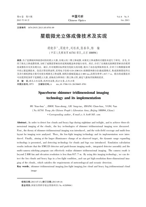
2013 年 10 月 第 6 卷 第 5 期 中国光学 Chinese Optics Vol. 6 No. 5 Oct. 2013文章编号 1674-2915(2013)05-0701-09星载微光立体成像技术及实现胡晓华 ∗ ,周晓中,刘松涛,张春华,杨 楠( 中国人民解放军 61741 部队,北京 100094 )摘要:为了监测夜间和晨昏时段的低云大雾,实现云的三维立体成像,对微光立体成像的关键技术进行了研究。
首先, 介 绍了微光立体成像原理,分析了成像需要解决的宽视场覆盖和多镜头布局。
然后,介绍了实现微光探测需要解决的低照 度成像技术及其实现方法。
最后 ,针对观测目标照度变化较大的问题, 提出了动态范围拓展技术, 介绍了后期数据处理 中的云雾监测技术。
仿真计算结果表明:采用电子倍增 CCD( EMCCD) 探测器和推扫扫描成像模式 、 集成探测器组件以 及多台相机拼接方案可有效实现微光立体成像,相机扫描幅宽超过 2 800 km; 高程分辨率 < 817. 7 m。
提出的成像技术 可在低照度条件下监测低云大雾,获取高分辨率的三维立体云图,满足气象海洋探测的需求。
关 键 词 :微光立体成像;低照度成像;低云大雾;立体云图 中图分类号 :TP73 文献标识码:A doi:10. 3788 / CO. 20130605. 0701Spaceborne shimmer tridimensional imaging technology and its implementationHU Xiao-hua ∗ , ZHOU Xiao-zhong, LIU Song-tao, ZHANG Chun-hua, YANG Nan ( No. 61741 Troop ,the Chinese People′s Liberation Army,Beijing 100094,China) ∗Corresponding author, E-mail:x. h. hu @ 163 . commensional imaging of the clouds, the key technologies of shimmer tridimensional imaging were discussed.Abstract : In order to detect low clouds and heavy fogs during nighttime and twilight, and to achieve three-diFirst, the theory of shimmer tridimensional imaging was introduced, and the wide-field coverage and multi-lens layout for imaging were analyzed. Then, the low-light imaging technology and its implementation were introtechnology is presented, and detecting technology for clouds and fogs was introduced. Emulation calculation results indicate that the EMCCD detector and push-broom imaging mode, integrated detector assembly and the multi-camera stitching program can effectively realize shimmer tridimensional imaging. The camera swath is beyond 2 800 km and elevation resolution is less than 817. 7 m. By using this imaging technology, we can de-duced. Finally, aiming at the larger illuminance change of an observed target, the dynamic range expandingtect the low clouds and heavy fogs in a low-light condition, and can get high-resolution three-dimensional imaging of the clouds, which satisfies the requirements of meteorologycal and oceanic detection. image Key words: shimmer tridimensional imaging;low-light imaging;low cloud and heavy fog;tridimensional cloud 收稿日期:2013-07-13 ;修订日期:2013-09-16 基金项目:国家自然科学基金资助项目( No. 41205004)702 中国光学 第 6 卷 1 引 言 低云大雾天气多产生于夜间和晨昏时段, 是 造成低能见度的主要天气现象,严重影响航海、航 空、公路运输安全[1]表目标进行推扫,可获取月表同一目标星下点、前 视 16. 7°、后视 16. 7° 3 幅二维原始数据图像, 经 辐射定标后重构月表三维立体影像。
CT术语及常见病名的中英文对照- -Tag:CT术语CT术语及常见病名的中英文对照A----------abscess of kidney 肾脓肿acoustic 听神经瘤acute pancreatitis 急性胰腺炎analog 模拟analog/digital converter 模拟/数字转化器angiography of spinal cord 脊髓血管造影angioma 血管瘤angiomyolipoma 血管平滑肌脂肪瘤anterior cerebral artery,ACA 大脑前动脉anterior communicating artery,AcoA 前交通动脉arachnoidcyst 蛛网膜囊肿arterior-venous malformation,AVM 动静脉畸形artifact 伪影astrocytoma 星形细胞瘤atelectasis 肺不张attenuation 衰减attenuation coefficient 衰减系数axial scan 轴位扫描B----------B basilar artery,BA 基底动脉Beam hardening artifact 射线硬化伪影biopsy gun 活检枪biopsy needle 活检针biphasic contrast enhancement 双期增强扫描bone mineral density,BMD 骨密度brain abscess 脑脓肿brain hemorrhage 脑出血brain trauma 脑外伤bronchiectsis 支气管扩张bronchogenic carcinoma 支气管肺癌C----------calcification of the pleura 胸膜钙化calculus of kidney 肾结石carcinoma of bladder 膀胱癌carcinoma of the cervix 宫颈癌carcinoma of kidney 肾癌carcinoma of prostate 前列腺癌carcinoma of ovary 卵巢癌cavity 空洞central bronchogenic carcinoma 中央型肺癌cerebral atrophy 脑萎缩cerebral contusion 脑搓伤cerebral infarction 脑梗塞cerebral ischemia 脑缺血cerebral cycticercosis 脑囊虫病cholesteatoma 胆脂瘤cholangiocarcinoma 胆管癌cholecystitis 胆囊炎chronic pancreatitis 慢性胰腺炎circle of willis 脑底动脉环cirrhosis 肝硬化collimator 准直器console 控制台contrast medium 对比剂contrast enhancement 对比增强contrast media bolus 造影剂团注contusion of kidney 肾挫伤contusion of spinal cord 脊髓挫伤coronal scan 冠状面扫描craniopharyngioma 颅咽管瘤CT angiography,CTA CT血管造影术CT arterial portography,CTAP CT动脉性门脉造影CT fluoroscopy CT透视CT guided needle biopsy CT导向穿刺活检CT guided fine needle aspiration biopsy CT导向细针抽吸活组织检查CT guided stereotaxis CT导向立体定位CT intervention CT介入CT muelography,CTM CT脊髓造影CT value CT值Cyst of Kinney 肾囊肿D----------delayed scan 延迟扫描density resolution 密度分辨率digital martrix 数字矩阵dynamic scanning 动态扫描E----------enhancement scan 增强扫描ependymoma 室管膜瘤epidural hematoma 硬膜外血肿F----------fatty liver 脂肪肝field of view,FOV 视野FWHM 有效层厚G----------gallbladder carcinoma 胆囊癌gallstone 胆石症golima 胶质瘤Graves’ disease 格氏眼病H----------hepatic cyst 肝囊肿hepatocellular 肝细胞癌high KV radiography 高千伏摄影high resolution CT,HRCT 高分辨率CThigh spatial-freqyency algorithm 高空间频率计算法重建hypaque 泛影钠I----------image post-processing 图象后处理image reconstruction 图象重建informatics in radiology,infoRAD 信息放射学interventional radiology 介入放射学iodipamide/biligrafin/cholografin 胆影葡胺iohexol 碘苯六醇(欧乃派克)iopromide 碘普罗胺isovist 伊索显L----------laser printer 激光打印机M----------matrix 矩阵maximum intensity projection,MIP 最大强度投影medulloblastoma 髓母细胞瘤meningioma 黑色素瘤motion artifact 运动伪影multiformat camera 多幅相机multiplanar reformation,MPR 多平面重建multiple sclerosis 多发性肝硬化N----------neurofibroma 神经纤维瘤noise 噪声O----------orbitomeatal line 听眶线overlap scan 重叠扫描P----------partial volume effect 部分容积效应peripheral space phenomenon 周围间隙现象picture achieve and communication system,PACS 图象存储和传输系统pitch 螺距pixel 像素plain scan 平扫pleural effusion 胸腔积液posterior cerebral artery,PCA 大脑后动脉preventive maintenace 日常维护程序protrusion of intervertebral disk 椎间盘突出Q----------quantitative computed tomography,QCT 定量CTR----------region of interest 兴趣区retinoblastoma 视网膜母细胞瘤S----------scout view 定位扫描slice increment 间距slice thickness 层厚spatial resolution 空间分辨率spinal srenosis 椎管狭窄spiral CT/helical CT 螺旋CTsubdural hematoma 硬膜下血肿T----------teleradiology 远程放射学temporal resolution 时间分辨率thin slice scan 薄层扫描three dimension computed tomography,3 DCT 三维CTthree-dimensional surface reconstrction,SSD 三维表面重建threshold 阈值tomography 体层摄影tuberculosis 肺结核U----------ultrafast CT,UFCT 超高速CTultravist 优维显urografin 泛影葡胺V----------vertebral artery,VA 椎动脉virtual endoscopy,VE 仿真内镜volume acquisition 容积采集volume scan 容积扫描voxel matrix 像素矩阵W----------window level 窗位window width 窗宽work station 工作站X----------Xeroradiography 干板照相X-ray tube X线球管Xenon,Xe 氙气关于CT方面的中英文对照:anterior pararenal space 肾旁前间隙aortopulmonary window level 主肺动脉窗层面bone window 骨窗CT angiography, CTA CT血管造影density resolution 密度分辨力distal of the aortic arch level 主动脉弓上层面dural sac 硬膜囊dynamic contrast-enhanced imaging 动脉增强扫描electron beam CT, EBCT 电子束CTfluid-fluid level 液-液平面four-chamber level “四腔心”层面higt resolution CT, HRCT 高分辨力CTHounsfield Unit HUintra/extra-capsular ligaments 囊内外韧带lateroconal fascia 侧锥筋膜left atrial level 左心房层面pericardial defect 心包缺损pericardial neoplasm 心包新生物pericardial effusions 心包渗出pericardial thickening and calaification 心包增厚和钙化pericardium 心包perirenal space 肾周间隙posterior pararenal space 肾旁后间隙pulmonary artery level 主肺动脉层面soft-tissue window 软组织窗spatial resolution 空间分辨力spiral CT 螺旋CTaortic arch level 主动脉弓层面ventricle level 心室层面头部急诊平扫Emergent Head Scan头部急诊增强Emergent Head Enhanced Scan头部平扫Head Routine Scan头部增强Head Enhanced Scan眼部平扫Orbits Routine Scan眼部增强Orbits Enhanced Scan内耳平扫Inner Ear Routine Scan内耳增强Inner Ear Enhanced Scan乳突平扫Mastoid Routine Scan乳突增强Mastoid Enhanced Scan蝶鞍平扫Sella Routine Scan蝶鞍增强Sella Enhanced Scan鼻窦轴位平扫Sinus Axial Routine Scan鼻窦轴位增强Sinus Axial Enhanced Scan鼻窦冠位平扫Sinus Coronal Scan鼻窦冠位增强Sinus Coronal Enhanced Scan鼻咽平扫Nasopharynx Routine Scan鼻咽增强Nasopharynx Enhanced Scan腮腺平扫Parotid Routine Scan腮腺增强Parotid Enhanced Scan喉平扫Larynx Routine Scan喉增强Larynx Enhanced Scan甲状腺平扫Hypothyroid Routine Scan甲状腺增强Hypothyroid Enhanced Scan颈部平扫Neck Routine Scan颈部增强Neck Enhanced Scan肺栓塞扫描Lung Embolism Scan胸腺平扫Thymus Routine Scan胸腺增强Thymus Enhanced Scan胸骨平扫Sternum Routine Scan胸骨增强Sternum Enhanced Scan胸部平扫Chest Routine Scan胸部薄层扫描High Resolution Chest Scan胸部增强Chest Enhanced Scan胸部穿刺Chest Puncture Scan轴扫胸部穿刺Axial Chest Punture Scan上腹部平扫Upper-Abdomen Routine Scan中腹部平扫Mid-Abdomen Routine Scan上腹部增强Upper-Abdomen Routine Enhanced Scan 中腹部增强Mid-Abdomen Routine Scan腹部穿刺Abdomen Puncture Scan轴扫腹部穿刺Axial Abdomen Puncture Scan颈椎平扫C-spine Routine Scan胸椎平扫T-spine Routine Scan腰椎平扫L-spine Routine Scan盆腔平扫Pelvis Routine Scan盆腔增强Pelvis Enhanced Scan骶髂关节平扫SI Joint Scan肩关节平扫Shoulder Joint Scan上肢软组织平扫Upper Extremities Soft Tissue Scan上肢软组织增强Upper Extremities Soft Tissue Enhanced 肘关节平扫Elbow Joint Routine Scan腕关节平扫Wrist Joint Routine Scan手部平扫Hand Routine Scan髋关节平扫Hip Joint Routine Scan膝关节平扫Knee Joint Routine Scan踝关节平扫Ankle Joint Routine Scan下肢软组织平扫Lower Extremities Soft Tissue Scan下肢软组织增强Lower Extremities Soft Tissue Enhanced 足部平扫Foot Routine Scan血管造影和三维成像头部血管造影Head CT Angiography颈部血管造影Neck CT Angiography心脏冠脉造影Coronal Artery Angiography心脏冠脉钙化积分Cardiac Calcium Scoring Scan胸部血管造影Chest CT Angiography腹部血管造影Abdomen CT Angiography上肢血管造影Upper Extremities CT Angiography下肢血管造影Lower Extremities CT Angiography五官三维成像3D Facial Scan胃三维3D Stomach CT Scan结肠三维3D Colon CT Scan颈椎三维3D C-Spine胸椎三维3D T-Spine腰椎三维3D L-Spine肩关节三维3D Shoulder Joint肘关节三维3D Elbow Joint腕关节三维3D Wrist Joint髋关节三维3D Hip Joint膝关节三维3D Knee Joint踝关节三维3D Ankle Joint检查名称英文对照头部平扫Head Routine Scan头部常规增强Head Routine Enhanced Scan 头部动态增强Head Dynamic Enhanced Scan 垂体平扫Sella Routine Scan垂体增强Sella Enhanced Scan鼻咽部平扫Nasopharynx Routine Scan鼻咽部增强Nasopharynx Enhanced Scan眼眶部平扫Orbits Routine Scan眼眶部增强Orbits Enhanced Scan内听道平扫Inner Ear Routine Scan颈部平扫Neck Routine Scan颈部普通增强Neck Enhanced Scan颈部动态增强Neck Dynamic Enhanced Scan上腹部平扫Upper Abdomen Scan上腹部普通增强Upper Abdomen Routine Enhanced 上腹部动态增强Upper Abdomen Dynamic Enhanced 中腹部平扫Mid-Abdomen Scan中腹部普通增强Mid-Abdomen Routine Enhanced中腹部动态增强Mid-Abdomen Dynamic Enhanced肾脏平扫Kidney Routine Scan肾上腺平扫Adrenal Routine Scan肾脏普通增强Kidney Routine Enhanced Scan肾脏动态增强Kidney Dynamic Enhanced Scan胰胆管造影MRCP尿路造影MRU腹和盆腔联合扫描Abdomen & Pelvis Scan颈椎平扫C-spine Scan颈椎增强C-spine Enhanced Scan胸椎平扫T-spine Scan胸椎增强T-spine Enhanced Scan腰椎平扫L-spine Scan腰椎增强L-spine Enhanced Scan胸腰段平扫T&L Spine Scan胸腰段增强T&L Spine Enhanced Scan胸部平扫Chest Scan胸部普通增强Chest Routine Enhanced Scan胸部动态增强Chest Dynamic Enhanced Scan女性盆腔平扫Female Pelvis Scan女性盆腔普通增强Female Pelvis Routine Enhanced女性盆腔动态增强Female Pelvis Dynamic Enhanced男性盆腔平扫Male Pelvis Scan男性盆腔普通增强Male Pelvis Routine Enhanced男性盆腔动态增强Male Pelvis Dynamic Enhanced肩关节平扫Shoulder Joint Scan肘关节平扫Elbow Joint Scan腕关节平扫Wrist Joint Scan手部平扫Hand Scan上肢软组织平扫Upper Soft Tissue Scan上肢软组织普通增强Upper Soft Tissue Routine Enhanced 上肢软组织动态增强Upper Soft Tissue Dynamic Enhanced骶髂关节平扫Sacrum Ilium Joint Scan髋关节平扫Hip Joint Scan膝关节平扫Knee Joint Routine Scan踝关节平扫Ankle Joint Routine Scan足部平扫Foot Routine Scan下肢软组织平扫Lower Soft Tissue Scan下肢软组织普通增强Lower Soft Tissue Routine Enhanced 下肢软组织动态增强Lower Soft Tissue Dynamic Enhanced上肢MRA Upper Extremities MRA下肢MRA Lower Extremities MRA心脏大血管造影Heart MR Angiography胸主动脉造影T-Artery MR Angiography腹主动脉造影Abd-Artery MR Angiography头部血管造影Head MR Angiography颈部血管造影Head MR Angiography盆腔血管造影Pelvis MR Angiography下腔静脉MRA Portal Vein MRAultrasound 超声ultrasonography 超声成像gray scale 灰阶real time imaging 实时成像B-mode ultrasound B型超声color Doppler ultrasound 彩色多普勒超声sonogram (echogram) 省像图probe 探头acoustic shadowing 声影angiography 血管造影digital subtration angiography (DSA) 数字减影血管造影digital radiography (DR) 数字X线摄影intraarterial DSA (IADSA) 动脉DSAintravenous DSA (IVDSA) 静脉DSAInterventional radiology 介入放射学Vascular interventional radiology 血管性介入放射学transcatheter embolization(TAE) 栓塞术emboliaztion agents 栓塞剂gelfoam 明胶海绵Ivalon 聚乙烯醇spring coil 弹簧圈detachable ballon 可脱球囊Seldinger technique 经股动脉穿刺术percutaneoius transluminal angioplasty(PTA) 经皮血管腔内成形术laster angioplasty 激光血管成形术atherectomy 粥样斑块切除术ultrasonic angioplasty 超声血管成形术metalic stent 金属内支架endovascular stent 血管内支架restenosis 再狭窄percutaneous balloon mitral valvuloplasty 经皮球囊二尖瓣成形术percutaneous balloon pulmonary valvuloplasty 经皮球囊肺动脉瓣成形术thrombolysis 血栓溶解transjugular intrahepatic portosystemic shunt (Tipss) 经颈静脉肝内门-体静脉分流术nonvascular interventional radiology 非血管性介入放射学percutaneous transhepatic cholangiography (PTC) 经皮经肝胆道造影percutaneous transhepatic biliary drainage (PTCD) 经皮经肝胆道引流术needle puncture biopsy 针刺活检percutaneous pyelostomy 经皮肾盂造瘘术常规位置:standard views;补充位置:supplementary views;前后位AP,anteroposterior;后前位PA,posteroanterior;侧位lateral;斜位oblique;轴位axial;切线位tangential;眼眶orbit鼻窦后前23°位、华氏位、顶颏位occipitomental,Waters;眼眶后前37°位、柯氏位、鼻颌位、枕额位occipitofrontal,Caldwell;视神经孔后前位,瑞氏位Rhese;颞骨temporal bone乳突侧位:15°侧位,劳氏位Law;25°侧位,许氏位Schuller;35°侧位,伦氏位Runstrom;斜位:后前(45°)斜位,斯氏位Stenvers;前后斜位、反斯氏位;岩部轴位:(仰卧45°)梅氏位Mayer;欧文氏位Owen;岩部前后位AP axial,Towne;拇指thumb拇指前后位Robert;手hand后前斜位pronation oblique;前后斜位supination oblique,ball-catcher's腕wrist舟骨位scaphoid;腕管位carpal tunnel;肘elbow小头位capitellum,鹰嘴位olecranon;髋hip侧位(蛙形位)frog-leg,侧位(仰卧水平投照)cross-table lateral,groin lateral;颈椎cervical spine第1、2颈椎前后位,张口位open-mouth,OMV;胸部chest侧卧位lateral decubitus,前凸位(前后位及后前位)apical lordotic;前弓位kyphotic;附:床旁portable;呼气像expiratory;高千伏摄影high kilovoltage radiography;腹部abdomen腹平片plain abdominal radiograph,abdominal plain film尿路仰卧前后位,尿路平片:KUB,plain film of kidney,ureters,bladder(仰卧)前后位supine abdominal radiograph;立位upright abdominal radiograph;乳腺breast钼靶X线摄影:mammogram,molybdenum target radiography;yanxingzaoyingjipositive contrast agent (阳性)negtive contrast agent (阴性)一、部位location:同侧ipsilateral;对侧contralateral;患侧affected side;健侧intact side;近侧proximal side;远侧distal side;移位deviation,shift,displacement;无移位nondisplaced;抬高elevation;下降descent,fall;邻接abutting,next to,secondary to;二、范围extent:局限localized,regional;弥散diffuse;三、分布distribution:单侧unilateral;双侧bilateral,(in)both(lung fields);对称symmetric;不对称asymmetric;孤立solita ry;散在scattered;融合confluence(confluent);中心性central;偏心性eccentric;周围的periphery,peripheral;主要predominantly,primarily;in a segmental or lobar distribution;(sth) on the left;i n the left lower zone;稀疏;集中;四、数目number:单发solitary,single;多发multiple;增多increase;减少decrease;消失disappear;五、大小size:大large;小small;扩大enlarge/enlargement;扩张dilatation;膨胀distention;缩小shrink;体积缩小loss of volume;狭窄stenosis,narrowing;闭塞occlusion,obliteration,emphraxis;生长速率rate of growth;倍增时间doubling time;直径小于3厘米less than 3cm in diameter;不超过1厘米(small nodules)10 mm or less in size;直径增长25% 25% increase in diameter;体积增大一倍doubling of volume;大小不同的of varying sizes;六、形状shape,morphology:点状dot(punctual,punctate);斑点状mottling,stippled;粟粒状miliary;结节状nodular;团块状m ass,masslike;圆形circular,round,rounded;卵圆形oval;椭圆形ellipse;长方形(椭圆形)oblo ng;分叶状lobulated;片状patchy;条索stripe;线状linar;网状reticular;囊状cystic;弧线形cur vilinear;星状stellate;纠集crowding,converging;舟状boat-shaped,navicular,scaphoid;哑铃状dumb-bell;不规则形irregular;细致fine;粗糙coarse;变形deformity;增粗、增厚thicken;变细、变薄thinning;变平flattened;七、边缘border,margin(marginated),rim,edge(edged);轮廓(外形)outline,contour;光滑(smooth);清晰,锐利(sharp,well-defined,well-circumscribed,clear,distinct);模糊hazy,indistinct,blurred,ill-defined,obscured,silhouette out (sth);不规则irregular;毛刺状、针状spiculated;分叶的lobulated,multilobulated;八、密度density(dense),densitometry,attenuation(X线成像):透亮lucency(lucent),transparent;病灶lesion:阴影shadow;不透光haziness,opacification,opacity,opaque;致密density(dense);低密度hypodense,low density;高密度hyperdense,high density;混杂密度mixed density;solid,subsolid(part solid),ground-glass(nonsolid)回声echo(echoic)(超声成像):* 无回声anecho,弱回声poor echo,低回声hypoecho,low level echo;等回声medium echo,iso -echo,高回声hyper echo,high level echo,强回声strong echo;信号signal(磁共振成像):低信号hypointensity;高信号hyperintensity;九、程度:轻度mild;slightly;中度moderately;重度severe;grossly;十、变化:一过性的,短暂的ephemeral;fleeting;transient;稳定stability(stable);密度水样密度watery density等密度isodense均匀密度homogeneous density不均匀密度nonhomogeneous density信号等信号isointensity混合信号heterogeneous intensity信号强度减弱decreased signal intensity信号强度增高increased signal intensity流空现象flow empty phenomena增强enhancement静脉团注法intravenous bolus injection technique 静脉快速滴注法intravenous rapid infusion增强扫描enhancement scan延迟扫描delayed scan动态扫描dynamic scan电影扫描cine scan增强前pre-enhancement pre-contrast增强后post-enhancement post-contrast动脉期arterial phase微血管期capillary phase静脉期venous phase延迟期delayed phase均匀增强homogeneous enhancement不均匀增强nonhomegeneous enhancement环状增强circular enhancement结节状增强nodular enhancement片状增强patchy enhancement脑回样增强gyriform enhancement边缘增强rim enhancementmedical imageology 医学影像学diagnostic radiology 放射诊断学x-ray diagnosis X线诊断imaging 影像contrast 对比resolution 分辨率fluoroscopy 荧光透视radiology 放射摄影tomography 体层摄影contrast agents (media) 造影剂protection from radiation 放射防护computed tomography (CT) 计算机体层摄影ct scanner CT扫描仪(CT机)analog/digital converter 模拟/数字转换器digital/analog converter 数字/模拟转换器voxel 体素pixel 象素spatial resolution 空间分辨率density resolution 密度分辨率Houlsfield unit CT值单位plain ct scan CT平扫contrast enhancement ct scan CT增强扫描convertional CT 常规CTspiral CT 螺旋CTultrafast ct (electric beam CT) 超高速CT(电子束CT)magnetic resonance imaging (MRI) 磁共振成像radio frequency (RF) 射频脉冲relaxation time 驰豫时间spin-lattice relaxation time 自旋-晶格(即纵向)(longitudinal relaxation time) 驰豫时间,简称T1spin-Spin(transverse) relaxation time 自旋-自旋(即横向)驰豫时间,简称T2spin-echo sequence (SE) 自旋回波序列echo time 回波时间repetitiontime 脉冲重复间隔时间(TR)T1 weighted (T1WI) image T1成像T2 weighted (T2WI) image T2成像magnetic resonance angiography (MRA) 磁共振血管成像flowing void effect 流空效应Time of flight (TOF) 时间流逝法phase contrast (PC) 相位对比法Gadolinium-DTPA (Gd-DTPA) 钆-二乙三胺五醋酸(磁显葡胺)检查名称英文对照头颅正侧位Skull PA & LAT鼻窦Sinus PA左侧乳突Left Mastoid Process右侧乳突Right Mastoid Process鼻骨侧位Nasal Bones LAT颈椎正侧位C-Spine PA & LAT颈椎双斜位C-Spine Dual Oblique胸椎正侧位T-Spine PA & LAT腰椎正侧位L-Spine PA & LAT骶尾正侧位Saccrum/Coccyx AP & LAT胸部正侧位(成人)Chest PA & LAT (Adult)胸部正侧位(儿童)Chest PA & LAT (Pediatrics)骨盆(成人)Pelvis PA (Adult)骨盆(儿童)Pelvis PA (Pediatrics)腹部(成人)Abdomen ( Adult)腹部(儿童)Abdomen (Pediatircs)左侧肩关节Left Shoulder Joint右侧肩关节Right Shoulder Joint左侧肱骨正侧位Left Humerus AP & LAT右侧肱骨正侧位Right Humerus AP & LAT左侧尺桡骨正侧位Left Forearm AP & LAT右侧尺桡骨正侧位Right Forearm AP & LAT左侧肘关节正侧位Left Elbow Joint AP & LAT右侧肘关节正侧位Right Elbow Joint AP & LAT左手正斜位Left Hand AP & Oblique右手正斜位Right Hand AP & Oblique左侧腕关节正侧位Left Wrist Joint AP & LAT右侧腕关节正侧位Right Wrist Joint AP & LAT双腕关节正位(成人)Dual Wrist Joint AP (Adult)双腕关节正位(儿童)Dual Wrist Joint AP (Pediatrics) 左侧股骨正侧位Left Femur AP & LAT右侧股骨正侧位Right Femur AP & LAT左侧膝关节正侧位Left Knee Joint AP & LAT右侧膝关节正侧位Right Knee Joint AP & LAT左侧胫腓骨正侧位Left Tibia Fibula AP & LAT右侧胫腓骨正侧位Right Tibia Fibula AP & LAT左侧踝关节正侧位Left Ankle Joint AP & LAT右侧踝关节正侧位Right Ankle Joint AP & LAT左侧足部正侧位Left Foot AP & LAT右侧足部正侧位Right Foot AP & LAT足跟侧位Calcaneus LAT检查方法名称英文对照胸部正位Chest PA胸部正侧位Chest PA & LAT心脏三位片Heart胸部斜位Chest OBL胸骨侧位Sternum LAT胸锁骨关节像Sternum Calvicle Joint PA锁骨正位Calvicle PA肩关节正位Shoulder Joint AP头颅正位Skull AP头颅正侧Skull AP & LAT颈椎正位C-spine AP颈椎张口位C-spine Open Mouth颈椎正侧位C-spine AP & LAT颈椎正侧双斜位C-spine AP & LAT & Dual OBL颈椎六位像C-spine 6 position颈椎正侧双斜张口位C-spine AP & LAT & Dual OBL Open Mouth 颈胸段正侧位C-T-spine AP & LAT胸椎正侧T-spine AP & LAT胸腰段正侧位T-L-spine AP & LAT腰椎正侧位L-spine AP & LAT腰椎正侧双斜L-spine AP & LAT & Dual OBL腰椎双斜L-spine Dual OBL腰椎六位像L-spine 6 position腰椎过伸过屈位L-spine Lordotic Kyphotic Position腰骶椎正侧位L-S-spine AP & LAT骶尾椎正侧位Saccrum/Coccyx AP & LAT尾椎侧位像Coccyx LAT骶髂关节正位Sacrum Ilium Joint AP骶髂关节切线位Sacrum Ilium Joint Tangential Position骨盆正位Pelvis AP耻骨坐骨正位Pubis Ischium AP常规位置:standard views;补充位置:supplementary views;前后位AP,anteroposterior;后前位PA,posteroanterior;侧位lateral;斜位oblique;轴位axial;切线位tangential;眼眶orbit鼻窦后前23°位、华氏位、顶颏位occipitomental,Waters;眼眶后前37°位、柯氏位、鼻颌位、枕额位occipitofrontal,Caldwell;视神经孔后前位,瑞氏位Rhese;颞骨temporal bone乳突侧位:15°侧位,劳氏位Law;25°侧位,许氏位Schuller;35°侧位,伦氏位Runstrom;斜位:后前(45°)斜位,斯氏位Stenvers;前后斜位、反斯氏位;岩部轴位:(仰卧45°)梅氏位Mayer;欧文氏位Owen;岩部前后位AP axial,Towne;拇指thumb拇指前后位Robert;手hand后前斜位pronation oblique;前后斜位supination oblique,ball-catcher's腕wrist舟骨位scaphoid;腕管位carpal tunnel;肘elbow小头位capitellum,鹰嘴位olecranon;髋hip侧位(蛙形位)frog-leg,侧位(仰卧水平投照)cross-table lateral,groin lateral;颈椎cervical spine第1、2颈椎前后位,张口位open-mouth,OMV;胸部chest侧卧位lateral decubitus,前凸位(前后位及后前位)apical lordotic;前弓位kyphotic;附:床旁portable;呼气像expiratory;高千伏摄影high kilovoltage radiography;腹部abdomen腹平片plain abdominal radiograph,abdominal plain film尿路仰卧前后位,尿路平片:KUB,plain film of kidney,ureters,bladder (仰卧)前后位supine abdominal radiograph;立位upright abdominal radiograph;乳腺breast钼靶X线摄影:mammogram,molybdenum target radiography;腹部平片Abdomen AP上肢Upper Extremities下肢Lower Extremities华氏位Waltz Position下颌骨正侧位Mandible PA_LAT头颅正侧位Skull PA_LAT颧弓切线位Zygomatic小儿胸片Chest膝关节造影Knee Joint Contrast肩关节造影Shoulder Joint Contrast椎管造影Spinal ContrastTMJ造影TMJ contrast腮腺造影Parotid Contrast静脉肾盂造影IVP逆行尿路造影Contrary Urethral Contrast子宫造影Uterus ContrastT管造影T-tube Cholangiography五官造影Facial Contrast窦道造影Contrast Fistulography瘤腔造影Tumor Cavity Contrast异物定位Orientation胆系造影CholecystographyERCP ERCP上消化道造影Upper Gastrointestinal Contrast全消化道造影Full Gastrointestinal Contrast钡灌肠造影Barium Contrast of Colon小肠低张造影Small Bowel Enema结肠低张造影Hypotonic Colon Contrast食道造影Contrast Esophagography关于X线方面的部分中英文对照:acromioclavicular joint 肩锁关节air bronchogram 支气管影像ankle joint 踝关节ankylosis of joint 关节强直arches of foot 足弓biligrafin 胆影葡胺bone age 骨龄bone canaliculi 骨小管bone cortex 骨皮质bone deformity 骨骼变形bone destruction 骨质破坏bone lacuna 骨陷窝bone lamella 骨板bony articular surface 骨关节面bursa 滑膜囊calcification 钙化carpal bones 腕骨cavity 空洞chondral calcification 软骨钙化compact bone and spongy bone 密质骨和松质骨degeneration of joint 关节退行性变destruction of joint 关节破坏diaphysis 骨干digital subtraction angiography, DSA 数字减影血管造影dislocation of joint 关节脱位dual photon absorptiometry, DPA 双光子吸收法dual X-ray energy absorptiometry, DXA 双能X线吸收法elbow joint 肘关节encapsulated effusion 包裹性积液end plate 终板epiphyseal line 骨骺线epiphyseal plate 骨骺板epiphysis 骨骺exudation 渗出fibrotic lesion 纤维性病变filling defect 充盈缺损free pleural effusion 游离性胸腔积液haemosiderosis 含钱血黄素沉着Hafersian system 哈弗系统haversian lamella 哈氏骨板hilar dance 肺门舞蹈hip joint 髋关节hydropneumothorax 液气胸hydroxyapatite crystal 羟基磷灰石结晶hyperostosis/osteosclerosis 骨质增生硬化intercondyloid eminence 髁间隆起interlobar effusion 叶间积液intermediate lamella 骨间板internal and external circumfereutial lamella 内、外环骨板interstitial pulmonary oedema 间质性肺水肿intervertebral disc 椎间盘intervertebral foramen 椎间孔intervertenral space 椎间隙intra-alveolar pulmonary oedema 肺泡性肺水肿joint 关节joint capsule 关节囊joint cartilage 关节软骨joint cavity 关节腔joint space 关节间隙knee joint 膝关节lamellar bone 层板骨left atrial enlargement 左心房增大left ventricular enlargement 左心室增大ligament 韧带localized pleural effusion 局限性胸腔积液looser zone 假骨折线mass 肿块medullary space 骨髓腔metacarpal bones 掌骨metaphysis 干骺端metatarsal bones 跖骨niche 龛影obstructive atelectasis 阻塞性肺不张obstructive emphysema 阻塞性肺气肿oral cholecystography 口服胆囊造影ossifcation 骨化ossification centre 骨化中心osteoblast 成骨细胞osteoclast 破骨细胞osteocyte 骨细胞osteomalacia 骨质软化osteonecrosis 骨质坏死osteoporosis 骨质疏松periosteal proliferation 骨膜增生periosteal reaction 骨膜反应periosteum and intermal periosteum 骨膜和骨内膜phalanges of fingers 指骨phalanges of toes 趾骨pleural thickening,adhesion and calaification 胸膜增厚、粘连及钙化pleural tumor 胸膜肿瘤pneumothorax 气胸proliferative lesion 增殖性病变pulmonary hilar enlargement 肺门增大pulmonary arterial hypertension 肺动脉高压pulmonary arterial pleonaemia 肺充血pulmonary hypertension 肺高压pulmonary oligaemia 肺少血pulmonary venous hypertension 肺静脉高压pulmonary venous pleonaemia 肺淤血quantitative computed tomography, QCT 定量CT法right atrial enlargement 右心房增大right ventricular enlargement 右心室增大sequestrum 死骨shoulder joint 肩关节soft tissue mass 软组织肿胀soft tissue swelling 软组织肿胀subpulmonary effusion 肺下积液swelling of joint 关节肿胀tarsal bones 跗骨tibia tuberosity 胫骨粗隆trabecula 骨小梁Volkmann canal 福尔克曼管woven bone 非层板骨wrist 腕关节abestosis 石棉肺acquired immunodeficiency syndrome, AIDS 艾滋病actinomycosis 放线菌病acute military tuberculosis 急性粟粒型肺结核agenesis and hypoplasia of the lung 肺不发育和肺发育不全allergic pneumonia 过敏性肺炎aluminum pneumoconiosis 铝尘肺amyloidosis of lung 肺淀粉样变性angiogram sign 血管造影征anthracosis 炭黑尘肺aspergillosis 曲菌病bronchiectasis 支气管扩张bronchogenic cyst 支气管囊肿bronchopneumonia 支气管肺炎broncho-pulmonary sequestration 支气管肺隔离症butterfly sign 蝶翼征cement pneumoconiosis 水泥尘肺chronic bronchitis 慢性支气管炎chronic pneumonia 慢性肺炎coalworker pneumoconiosis 煤工尘肺congenital bronchial cysts 先天性支气管囊肿contusion of lung 肺挫伤cryptococcosis 隐球菌病cylindrical bronchiectasis 柱状支扩dermoid cyst 皮样囊肿diaphragmatic eventeration 膈膨升diaphragmatic hermia 膈疝electric welder pneumoconiosis 电焊工尘肺esophageal cyst 食管囊肿foreign body of chest 胸部异物foundry worker pneumoconiosis 铸工尘肺Goodpasture syndrome 肺-肾综合征graphite pneumoconiosis 石墨尘肺halo sign 晕轮征hamartoma 错构瘤hematogenous pulmonary tuberculosis 血行播散型肺结核(II型)Hodgkin lymphoma 霍奇金淋巴瘤Hodgkin disease, HD 霍奇金病honeycomb lung 蜂窝状肺hydropneumothorax 液气胸inflammatory pseudotumor 炎性假瘤interstitial pneumonia 间质性肺炎intrathoracic goiter 胸内甲状腺kaolin pneumoconiosis 陶工尘肺Kaposi sarcoma 卡波济肉瘤laceration and hematoma of lung 肺撕裂伤与肺血肿laceration of trachea and bronchus 气管及支气管裂伤lipoma 脂肪瘤lobar pneumonia 大叶性肺炎Loffler syndroma 吕弗留综合征lung abscess 肺脓肿lymphangioma 淋巴管瘤lymphoma 淋巴瘤mediastinal emphysema 纵隔气肿mediastinal hematorma 纵隔血肿mediastinal tumor 纵隔肿瘤mediastinitis 纵隔炎mesothelial cyst 间皮囊肿mesothelioma of pleura 胸膜间皮瘤metastatic tumor of pleura 胸膜转移瘤mica pneumoconiosis 云母尘肺neurogenic neoplasms 神经源性肿瘤non Hodgkin lymphoma, NHL 非霍奇金淋巴瘤pleural thickening, adhesion and calcification胸膜肥厚粘连和钙化pleuro-peritoneal hiatus hernia 胸腹裂孔疝pneumocomosis 尘肺pneumomediastinum 纵隔气肿pneumothorax 气胸primary complex 原发综合征primary tuberculosis 原发性肺结核(I型)pulmonary alveolar microlithiasis 肺泡微石症pulmonary alveolar proteinosis 肺泡蛋白沉积症pulmonary arterio-venous fistula 肺动静脉瘘pulmonary arterio-venous malformation,PAVM肺动静脉畸形pulmonary connective tissue diseases 肺结缔组织疾病pulmonary edema 肺水肿pulmonary emboli 肺梗塞pulmonary infarcts 肺梗死pulmonary sequestration 肺隔离症pulmonary tuberculosis 肺结核pyothorax 化脓性胸膜炎radiation pneumonitis 放射性肺炎rheumatoid disease of the lung 肺类风湿性病saccular bronchiectasis 囊状支扩sarcoidosis 结节病secondary pulmonary tuberculosis 继发性肺结核(III型)seminoma 精原细胞瘤silicosis 矽肺staphylococal pneumonia 葡萄球菌肺炎subacute or chronic hematogenous pulmonary tuberculosis亚急性或慢性血行播散型肺结核systemic lupus erythomatosis, SLE 系统性红斑狼疮talc pneumoconiosis 滑石尘肺teratoma 畸胎瘤thymoma 胸腺瘤tramline sign 轨道征traumatic diaphragmatic hernia 外伤性隔疝tuberculosis of intrathoracic lymph nodes胸内淋巴结结核tuberculosis pleuritis 结核性胸膜炎varicose bronchiectasis 静脉曲张型支扩Wegner granuloma 韦格氏肉芽肿下肢静脉造影Lower Vein Angiography上肢静脉造影Upper Vein Angiography下肢动脉造影Lower Artery Angiography上肢动脉造影Upper Artery Angiography脑血管造影Cerebrovascular Angiograhy主动脉弓胸腹主动脉造影Aorta Angiography肾静脉取血Kidney Vein Blood Sampling右心、左心造影Right and Left Ventricular Angiography心肌活检Myocardiam Centesis and Sampling冠状动脉造影Coronary Arteriography腔静脉取血Vena cava sampling心导管检查(微导管同)(进口仪器)Cardiac catheterization经皮球囊扩张Percutaneous balloon dilatating予激综合症心内膜检测Endocardial investigation of preexcitation syndrome希氏束电图Electrocardiogram of bundle of His心脏临时起搏Cardiac temporary pacing埋置永久心脏起搏器Cardioc permanent pacemaker implanting体肢动脉系统介入治疗Transartery interventional therapy支气管动脉介入治疗Bronchus artery interventional therapy肺动脉介入治疗Pulmonary artery interventional therapy头臂动脉介入治疗Brachiocephalic artery interventional therapy静脉介入治疗Veinous interventional therapy冠状动脉介入治疗(球囊成形) Coronary Artery interventional therapy (balloon angioplasty) 冠状动脉介入治疗(腔内旋磨) Coronary Artery interventional therapy (rotablating)冠状动脉介入治疗(腔内支架) Coronary Artery interventional therapy (stent implantaion) 主动脉介入治疗Aorta interventional therapy肾动脉介入治疗Renal artery interventional therapy心脏瓣膜成形术Heart valvuloplasty房间隔缺损封堵术Atrial septal defect closer室间隔缺损封堵术Ventricular septal defect closer。
Ex. 111.Improvement of the accuracy of range alignment in ISAR imaging by using thesuper resolution technique.采/运用超分辨方法改善ISAR(信息储存与检索)图像中距离校正的精确度2.Analysis of the ability of a quartz flexibility accelerometer to resist adverse/badenvironment.石英挠性加速度计/仪抵御不良环境的能力分析3. A spectral analysis of the EMI at the input of the SMPS and its suppression开关电源输入端的电脑干扰频谱分析及其抑制4.Also, a quantitative expression for the effect of all these factors on theperformance of the system is derived, on the basis of which an improved system is presented/proposed.同时,本文推导出了所有这些因素对系统性能影响的定量表达式,在此基础上提出了一种改进型/版系统。
5.The performance of the system has been improved (by) 14 – 30 dB on conditionthat the complexity of the system remains unchanged.在不增加复杂程度的条件下,该系统性能已提高14-30分贝。
6.Measurements are generally of three groups: those made of capacitance, those(made) of current and those (made) of voltage.一般,测量可以分为三种,即电容测量、电流测量和电压测量。
光学层析成像的英文Optical Coherence Tomography: A Revolutionizing Imaging TechniqueOptical coherence tomography (OCT) is a non-invasive, high-resolution imaging technique that has revolutionized the field of medical diagnostics. This advanced technology utilizes the principles of light interference to produce detailed, cross-sectional images of biological tissues, allowing healthcare professionals to gain unprecedented insights into the internal structures of the human body.At the core of OCT is the concept of interferometry, a technique that measures the interference pattern of light waves to determine their properties. In an OCT system, a low-coherence light source, typically a near-infrared laser, is split into two separate beams. One beam is directed towards the target tissue, while the other serves as a reference beam. As the light interacts with the tissue, it is reflected back and recombined with the reference beam. The interference pattern created by the two beams is then analyzed to generate a high-resolution, three-dimensional image of the tissue's internal structure.The remarkable capabilities of OCT are rooted in its ability to capture images with micrometer-scale resolution, far surpassing the limitations of traditional imaging techniques such as ultrasound or X-ray. This precision allows healthcare professionals to detect and diagnose a wide range of medical conditions with unprecedented accuracy. From ophthalmology to cardiology, OCT has become an invaluable tool in the early detection and management of various diseases.In the field of ophthalmology, OCT has revolutionized the way eye diseases are diagnosed and treated. The technique's ability to produce detailed images of the retina, optic nerve, and other ocular structures has enabled clinicians to identify subtle changes and abnormalities that were previously undetectable. This has led to improved diagnosis and management of conditions such as age-related macular degeneration, glaucoma, and diabetic retinopathy, ultimately enhancing patient outcomes and preserving vision.Beyond ophthalmology, OCT has found applications in various other medical specialties. In cardiology, OCT is used to assess the integrity of coronary artery walls, identifying plaque buildup and potential areas of vulnerability. This information is crucial for the early detection and management of cardiovascular diseases, allowing clinicians to develop targeted treatment strategies and improvepatient outcomes.In the field of dermatology, OCT has become a valuable tool for the diagnosis and monitoring of skin conditions. The technique's ability to generate high-resolution images of the skin's layers, including the epidermis, dermis, and even the subcutaneous tissue, has enabled clinicians to identify and track the progression of skin cancers, inflammatory disorders, and other dermatological conditions with remarkable precision.The versatility of OCT extends beyond the medical field, as it has also found applications in materials science, engineering, and even art conservation. In materials science, OCT is used to analyze the internal structure and composition of various materials, from semiconductors to works of art. This information is crucial for understanding the properties and performance of these materials, as well as for the preservation and restoration of cultural heritage objects.As technology continues to advance, the potential of OCT continues to grow. Researchers are exploring the development of new light sources, detection methods, and image processing algorithms to further enhance the capabilities of this remarkable imaging technique. Additionally, the integration of OCT with other imaging modalities, such as fluorescence imaging or Raman spectroscopy, is opening up new avenues for multimodal imaging and advanceddiagnostics.In conclusion, optical coherence tomography is a transformative imaging technology that has had a profound impact on various fields, from medical diagnostics to materials science. Its ability to provide high-resolution, non-invasive imaging of internal structures has revolutionized the way healthcare professionals approach the detection, diagnosis, and management of a wide range of medical conditions. As the technology continues to evolve, the future of OCT holds immense promise, paving the way for even more groundbreaking advancements in the years to come.。
三维荧光光谱英语Three-Dimensional Fluorescence Spectroscopy: Principles, Applications, and Future Prospects.Fluorescence spectroscopy is a powerful analytical tool that has found widespread applications in various fields ranging from biochemistry to environmental science. Traditionally, fluorescence spectroscopy has been primarily based on two-dimensional (2D) representations, such as excitation-emission matrices (EEMs). However, with the advent of advanced instrumentation and data processing techniques, three-dimensional (3D) fluorescencespectroscopy has emerged as a more comprehensive and informative approach.Principles of Three-Dimensional Fluorescence Spectroscopy.Three-dimensional fluorescence spectroscopy involvesthe measurement of fluorescence intensity as a function ofboth excitation and emission wavelengths, resulting in a three-dimensional dataset. This dataset can be represented as a fluorescence landscape or cube, where each point on the cube corresponds to a specific excitation-emission wavelength pair and the associated fluorescence intensity.The key principle underlying 3D fluorescence spectroscopy is the ability to resolve overlapping fluorescent components present in a complex mixture. This is achieved by analyzing the spectral features of each component in three dimensions, rather than just two. By doing so, 3D fluorescence spectroscopy can provide a more detailed and accurate representation of the fluorescence properties of the sample.Applications of Three-Dimensional Fluorescence Spectroscopy.1. Environmental Science: 3D fluorescence spectroscopy has been widely used in environmental science for the analysis of dissolved organic matter (DOM) in aquatic systems. DOM plays a crucial role in aquatic ecosystems,affecting water quality, biogeochemical cycling, and thefate of contaminants. By employing 3D fluorescence spectroscopy, researchers can characterize the composition and distribution of DOM, gaining insights into its origin, degradation, and ecological implications.2. Biochemistry and Biomedicine: In the field of biochemistry and biomedicine, 3D fluorescence spectroscopy has found applications in the study of protein-ligand interactions, DNA/RNA analysis, and cellular metabolism. By analyzing the fluorescence signatures of biomolecules in three dimensions, researchers can gain a deeper understanding of their structural and functional properties, as well as their interactions with other molecules.3. Food Science and Technology: Three-dimensional fluorescence spectroscopy has also been applied in food science and technology for the quality assessment and authentication of food products. Fluorescence spectroscopy can provide information about the presence andconcentration of various components in food, such as pigments, fats, and proteins. This information can be usedto monitor the freshness, authenticity, and safety of food products.Future Prospects of Three-Dimensional Fluorescence Spectroscopy.With the continuous development of instrumentation and data analysis techniques, the future of 3D fluorescence spectroscopy looks promising. Future research in this field is expected to focus on several areas:1. Advanced Instrumentation: The development of more sensitive and robust instrumentation will further enhance the capabilities of 3D fluorescence spectroscopy. This includes the development of new excitation sources, detectors, and optical components that can improve the signal-to-noise ratio and spectral resolution.2. Advanced Data Analysis Techniques: As the complexity of fluorescence datasets increases, the development of advanced data analysis techniques becomes crucial. Future research will likely focus on the development of algorithmsand methods that can effectively handle large and complex fluorescence datasets, extracting meaningful information and insights.3. Multimodal Analysis: The integration of 3D fluorescence spectroscopy with other spectroscopic and imaging techniques, such as Raman spectroscopy, infrared spectroscopy, and microscopy, will provide a more comprehensive understanding of the sample. This multimodal analysis approach can help researchers gain a deeper understanding of the structure, composition, and dynamics of complex systems.4. Real-Time Monitoring and Automation: The development of real-time monitoring and automation capabilities will enable 3D fluorescence spectroscopy to be used in online and in-process applications. This will help improve the efficiency and accuracy of monitoring and control tasks in various industries, such as environmental monitoring, food processing, and biotechnology.In conclusion, three-dimensional fluorescencespectroscopy has emerged as a powerful analytical tool that offers unique insights into the fluorescence properties of complex systems. With the continuous development of instrumentation and data analysis techniques, its applications in various fields are expected to expand further, leading to new scientific discoveries and technological advancements.。
肌肉横截面积面积英文单词Muscle Cross-Sectional AreaMuscle is a remarkable tissue that plays a crucial role in the human body. From facilitating movement and maintaining posture to powering our daily activities, muscles are the driving force behind our physical abilities. At the heart of this muscular prowess lies a fundamental concept – the muscle cross-sectional area.The cross-sectional area of a muscle refers to the area occupied by the muscle fibers when viewed in a perpendicular plane. This measurement is significant because it directly correlates with the muscle's ability to generate force and power. The larger the cross-sectional area, the greater the potential for muscular strength and performance.Factors Affecting Muscle Cross-Sectional AreaThe cross-sectional area of a muscle is influenced by a variety of factors, both genetic and environmental. Genetics play a crucial role in determining an individual's muscle fiber type, distribution, and potential for growth. Some people are simply born with a predisposition to having larger muscle fibers, which can translate toa greater cross-sectional area.In addition to genetics, external factors such as physical activity and nutrition also have a significant impact on muscle cross-sectional area. Regular exercise, particularly resistance training, stimulates the muscle fibers to undergo hypertrophy, or an increase in size. This process is driven by the body's adaptive response to the stress placed on the muscles during strength-based activities.Proper nutrition, particularly the intake of adequate protein, is also essential for muscle growth and maintenance of cross-sectional area. Protein provides the building blocks for the synthesis of new muscle fibers and the repair of damaged ones, allowing the muscles to grow and maintain their size.Measuring Muscle Cross-Sectional AreaAccurately measuring the cross-sectional area of a muscle is crucial for assessing an individual's muscular development, monitoring progress, and informing training and nutritional strategies. Several techniques are available for this purpose, each with its own advantages and limitations.One of the most common methods is the use of magnetic resonance imaging (MRI) or computed tomography (CT) scans. These imaging techniques allow for high-resolution, three-dimensional visualizationof the muscle structures, enabling precise measurement of the cross-sectional area. This approach is particularly useful for evaluating deeper muscles that are not easily accessible through physical examination.Another method involves the use of ultrasound imaging. This non-invasive technique uses sound waves to create real-time images of the muscle, allowing for quick and relatively accurate measurements of the cross-sectional area. Ultrasound is often preferred for its accessibility, portability, and the ability to capture dynamic muscle contractions.In some cases, more indirect methods, such as anthropometric measurements or bioelectrical impedance analysis, can be used to estimate muscle cross-sectional area. These techniques rely on correlations between body measurements, body composition, and muscle size, but may not provide the same level of precision as direct imaging methods.Applications of Muscle Cross-Sectional AreaThe knowledge of muscle cross-sectional area has numerous practical applications in various fields, including sports science, rehabilitation, and clinical medicine.In the realm of sports and athletics, measuring muscle cross-sectional area is crucial for evaluating an athlete's muscular development and potential for strength and power generation. Coaches and trainers can use this information to design tailored training programs, track progress, and identify areas for improvement. Additionally, this data can be used to compare an athlete's muscle characteristics with those of elite performers in the same sport, providing valuable insights for optimal performance.In the field of rehabilitation, the assessment of muscle cross-sectional area plays a pivotal role in monitoring the recovery and progress of individuals undergoing physical therapy or recovering from injuries. Reductions in muscle size, known as atrophy, can occur due to immobilization, disuse, or neurological conditions. By tracking changes in muscle cross-sectional area, healthcare professionals can develop targeted interventions to restore muscle function and optimize the rehabilitation process.In clinical medicine, the evaluation of muscle cross-sectional area is increasingly being used as a marker of overall health and physical function. Reduced muscle size, or sarcopenia, is associated with various age-related conditions, such as frailty, metabolic disorders, and chronic diseases. By quantifying muscle cross-sectional area, healthcare providers can identify individuals at risk of these conditions and implement appropriate interventions to maintain or improve muscle health.ConclusionThe muscle cross-sectional area is a fundamental concept in the realm of human physiology and performance. This measurement reflects the size and potential of our muscular system, serving as a crucial indicator of strength, power, and overall physical well-being. Understanding the factors that influence muscle cross-sectional area and the techniques used to measure it enables us to better understand, monitor, and optimize our physical capabilities, whether in the realm of sports, rehabilitation, or general health and wellness. As our knowledge in this field continues to evolve, the applications of muscle cross-sectional area will undoubtedly expand, providing valuable insights and guiding us towards a deeper understanding of the human body and its incredible potential.。
关于投影仪的说明作文英语英文回答:Projectors have become an essential tool in various settings, from classrooms and conference rooms to home theaters. They offer a convenient and cost-effective way to display presentations, movies, and other visual content on a large screen. With advancements in technology, projectors have evolved significantly, showcasing improved picture quality, portability, and versatility.Choosing the right projector can be a daunting task considering the myriad of options available. To make an informed decision, it's crucial to first determine your intended usage and environment. For instance, if you need a projector for business presentations, you'll likely prioritize portability and image quality. On the other hand, if you're seeking a projector for home entertainment, factors such as screen size, brightness, and resolution become essential.Once you've established your requirements, it's time to delve into the technical aspects of projectors. The most important considerations include:- Resolution: Resolution refers to the number of pixels that make up the projected image. Higher resolutions result in sharper and more detailed images.- Brightness: Brightness is measured in lumens and determines how well the projector can overcome ambient light. For environments with high ambient light, a brighter projector is necessary.- Contrast ratio: Contrast ratio is the ratio of the brightest white to the darkest black that the projector can produce. A higher contrast ratio ensures more vibrant images with deeper blacks.- Throw distance: Throw distance is the distance betweenthe projector and the screen. This measurement determines how large an image you can project at a given distance.- Lamp life: Lamp life is the estimated number of hours the projector lamp will last before requiring replacement.- Portability: If you plan on using the projector on the go, portability should be a key consideration. Look for models that are lightweight and easy to transport.In addition to these factors, there are several other features that can enhance your projector experience. Wi-Fi connectivity allows you to wirelessly stream content from your laptop, tablet, or smartphone. Built-in speakers provide audio without the need for external speakers. 3D projectors offer an immersive viewing experience with three-dimensional content.With the right projector, you can transform any space into a cinematic experience. Whether you're presenting abusiness proposal, hosting a movie night, or simply enjoying your favorite shows, a projector can bring your visual content to life with stunning clarity and detail.中文回答:投影仪已经成为了各种场所中的必备工具,从教室和会议室到家庭影院。
光声效应英语The Photoacoustic Effect in EnglishThe photoacoustic effect, also known as the Opto-acoustic effect, is a fascinating phenomenon that has captured the attention of scientists and researchers across various fields. This effect occurs when a material absorbs light, and the energy of the absorbed light is converted into sound waves. This process has numerous applications, ranging from medical diagnostics to environmental monitoring, and has become an area of intense study and exploration.The photoacoustic effect was first observed by Alexander Graham Bell in 1880, when he discovered that certain materials, when exposed to intermittent light, produced sound. This discovery laid the foundation for the development of various photoacoustic techniques and technologies. The underlying principle of the photoacoustic effect is the conversion of light energy into thermal energy, which then generates acoustic waves.When a material absorbs light, the energy of the absorbed photons is converted into heat. This heat causes the material to expand and contract, creating pressure waves that propagate through thematerial as sound waves. The characteristics of these sound waves, such as their frequency and amplitude, depend on the properties of the material and the incident light.One of the key advantages of the photoacoustic effect is its ability to provide non-invasive and non-destructive methods for analyzing and imaging various materials and structures. In the medical field, the photoacoustic effect has been used to develop imaging techniques that can detect and monitor various diseases and conditions, such as cancer, cardiovascular diseases, and brain disorders. By using light to generate sound waves, photoacoustic imaging can provide detailed information about the structure and function of tissues without the need for invasive procedures.Another important application of the photoacoustic effect is in the field of environmental monitoring. Photoacoustic spectroscopy can be used to detect and measure the concentration of various gases and pollutants in the atmosphere, as different molecules have unique absorption spectra that can be detected using this technique. This has led to the development of portable and highly sensitive gas sensors that can be used for air quality monitoring, leak detection, and other environmental applications.The photoacoustic effect has also found applications in materials science and engineering. By studying the photoacoustic response ofmaterials, researchers can gain insights into their physical and chemical properties, such as their thermal, optical, and mechanical characteristics. This information can be used to develop new materials and optimize existing ones for various applications, such as energy storage, catalysis, and optoelectronics.Furthermore, the photoacoustic effect has been exploited in the field of photoacoustic tomography, which is a powerful imaging technique that can provide high-resolution, three-dimensional images of the internal structure of materials and biological samples. This technique has been used for a wide range of applications, including the study of plant physiology, the detection of subsurface defects in materials, and the imaging of small animals for biomedical research.Despite the numerous applications and benefits of the photoacoustic effect, there are still many challenges and areas of ongoing research. One of the key challenges is to improve the sensitivity and resolution of photoacoustic techniques, particularly in the context of medical imaging and environmental monitoring. Researchers are also exploring ways to integrate photoacoustic technologies with other sensing and imaging modalities, such as ultrasound and optical coherence tomography, to create more comprehensive and informative diagnostic and monitoring systems.In conclusion, the photoacoustic effect is a remarkable phenomenon that has revolutionized various fields of science and technology. From medical diagnostics to environmental monitoring, the ability to convert light into sound waves has opened up new avenues of exploration and innovation. As research in this field continues to advance, we can expect to see even more remarkable applications and breakthroughs in the years to come.。
Improved resolution three-dimensional integral imaging using optimized irregularlens-array structureZahra Kavehvash,1,*Khashayar Mehrany,1and Saeed Bagheri21Department of Electrical Engineering,Sharif University of Technology,P.O.Box11365-8639,Tehran,Iran 2Philips Research North America,345Scarborough Road,Briarcliff Manor,New York10510,USA*Corresponding author:zkavehvash@Received29May2012;revised26July2012;accepted26July2012;posted26July2012(Doc.ID169490);published24August2012A rigorous approach is proposed to improve the resolution of integral imaging(InI)by finding the appro-priate form of irregularity in the arrangement of the InI lenslets.The improvement of the resolution isachieved through redistribution of the sampling points in a uniform manner.The optimization process forfinding the optimum pattern of the lens-array irregularity is carried out by minimizing a cost function,whose mathematical closed-form expression is provided.The minimization of the proposed cost functionensures the uniform distribution of sampling points and thus improves the resolution within the desireddepth of field(DOF)and field of view(FOV).A set of standard resolution charts is used to demonstratethe improvement of the quality of the three-dimensional(3D)images obtained by using the optimizedirregular lens array.It is shown that the overall level of the lateral and depth resolutions is improved atthe same time.©2012Optical Society of AmericaOCIS codes:110.6880,110.3000.1.IntroductionThree-dimensional(3D)integral imaging(InI)does not require wearing special eyeglasses to provide autostereoscopic images from a continuous view-point[1–6]and thus counts among the promising 3D imaging methods to be used for commercial3D visualization.Although more than a century-old technique[1],it has recently attracted increasing at-tention thanks to the renewed interest in3D imaging [7].A conventional InI system captures the visual in-formation of a3D object through a regular flat lens array and forms a bunch of elemental images(EIs). Since each EI provides a different perspective of the 3D object,the original3D object is reconstructed once the EIs are displayed on an optical device placed in front of a similar lens array.Despite the many-sided advantages brought by using the InI system,the reconstructed3D images have limited depth of field(DOF)and field of view (FOV)together with a low level of lateral and depth resolution.Many researches have been conducted to improve InI by adding different sorts of irregularity to the conventionally used flat lens array having si-milar lenslets.DOF improvement is already reported when curved lens arrays[8],and flat lens arrays made of lenslets with different focal lengths are em-ployed for InI[9].FOV improvement is also reported when appropriately curved lens arrays are used [10–12].The possibility of achieving a higher level of depth and lateral resolution by finding and adding the proper form of irregularity is,however,not a very well-studied subject.Such a study necessitates a quantitative gauge to measure the level of achiev-able lateral and depth resolution in InI systems. This has not been possible until very recently,when object-independent models based on the concept of1559-128X/12/256031-07$15.00/0©2012Optical Society of America1September2012/Vol.51,No.25/APPLIED OPTICS6031sampling rays were introduced to quantify the lateral and depth resolution[13].A sampling ray connects the center of each pixel on the display de-vice to the center of the corresponding lens in the lens array and thus carries the information necessary for image reconstruction[13–15].The intersection point of each sampling ray and the image plane is referred to as the sampling point[13].Given that two or even more sampling rays can intersect with each other at a specific image plane,the concept of the order of the sampling points was introduced to enumerate the in-tersecting sampling rays.The n th-order sampling point was thus defined to designate the intersection of n 1sampling rays.In the most recent work on the subject,the total number of the first-order sam-pling points is related to the lateral resolution of the InI system while the depth resolvability of different points of the image domain is related to the order of its sampling point[13].In this fashion,the depth and lateral resolution of the InI system is measured and a mathematical cost function is proposed to find the appropriate irregular pattern of the lens array that improves both lateral and depth resolvability in the desired DOF and FOV range.This is,to the best of our knowledge,the first attempt to propose a rigorous approach for finding the optimum irregu-lar pattern achieving higher depth and lateral resolution.The structure of this paper is as follows:we first introduce the overall structure of an irregular lens array,extract the coordinates of the k th-order sam-pling points,and optimize the structure to ensure a more uniform distribution of sampling points—all in Section2.We then present the simulation results in Section3and thus confirm the claimed improvement observed in the quality of the images reconstructed by using the optimized irregular lens array.Finally,we make the conclusions in Section4.2.Optimized Irregular Lens-Array PatternIt is already shown that the distribution of the sampling points is rather nonuniform whenever con-ventional flat lens arrays made of similar lenslets are employed[13].Quite often,the sampling points get accumulated at specific image planes.Since the high-er density of sampling points warrants a higher lat-eral resolution,any such plane is referred to as the lateral resolution plane.Likewise,a lower number of higher-order sampling points occasionally pile up at some other image planes.Since the presence of higher-order sampling points ensures a good depth resolvability,this latter type of planes is referred to as the depth resolution plane.Given that the high-order sampling points are formed by the inter-section of more sampling rays,there is a trade-off be-tween the number and order of sampling points at each lateral image plane and thus the good lateral resolution in the lateral resolution planes is bought at the expense of the depth resolvability[10].It is therefore conceivable that the uniform distribution of sampling points would be very much desired. Therefore,we are trying to rearrange the samplingrays in such a manner that the sampling pointsof different orders become uniformly distributed within the imaging space.This can be achieved byintroduction of a meticulous irregularity in the posi-tion and direction of the lenslets in the lens-array structure.Using the Cartesian coordinate system,it is hereassumed that the3D objects are to be reconstructedwithin a specific region lying between z z1,z z2, x x1,x x2,y y1,and y y2.This specific regionis hereafter referred to as the region of interest(RoI).It is within the RoI that the distribution of thespatial coordinates of the sampling points and their orders is tried to be made uniform.First,a conven-tional regular lens array is made irregular to showthat the distribution of the sampling points of differ-ent orders can be controlled.Then,the coordinates ofthe n th-order sampling points lying within the RoIare extracted in terms of the position and direction of the lenslets in a lens array with arbitrary irregu-larity.The appropriate cost function to be used foroptimizing the irregular pattern of the lenslets is finally introduced.A.Irregular Lens-Array StructureAn irregular lens array with an arbitrary pattern is schematically shown in Fig.1.Three different crosssections of the structure in the xy,yz,and xz planes(front view,top view,and left view)are shown in Figs.1(a),1(b),and1(c),respectively.Assuming thatthe original flat lens array was originally placed inthe xy plane,the p,q th lenslet of the array is shifted along the z-axis by s pq,and rotated byθx;pq andθy;pqaround the x-and y-axes,respectively.Insofar as thesampling ray connects an arbitrary input pixel of a specific EI,viz.P1in Figs.1(b)and1(c),to the centerof its corresponding lens,the irregularity of thelenslets—controlled by s pq,θx;pq,andθy;pq—affects the spatial arrangements of the sampling rays.Thisis clearly demonstrated in Figs.1(b)and1(c),wherethe sampling rays of the input pixel P1in the regular and irregular lens arrays are plotted by dashed andsolid lines,respectively.Once the sampling rays arerearranged by changing s pq,θx;pq,andθy;pq,the popu-lation of the sampling points of different orders is controlled within the RoI.This point is further expounded below,where the coordinates of the n th-order sampling points are extracted.B.Extraction of the n th-Order Sampling PointsThe coordinates of all sampling points can be easilyextracted once the algebraic equation of each sam-pling ray emanating from the i,j th pixel of the p;q th EI is given.Since each sampling ray passes through the center of its corresponding lenslet in the array,the governing equation of a typical sam-pling ray can be written in terms of its pixel co-ordinates x i;y j;−g ,and its lenslet coordinates x p;y q;s pq :6032APPLIED OPTICS/Vol.51,No.25/1September2012z g s pq x −x ix p i y −y j y q j.(1)Here,g is the distance between the display device and the lens-array plane.It should be pointed out that the sampling ray passing through the p;q th lenslet lies within the FOV of the lenslet:αx and αy along the x and y directions,respectively.Therefore,the following two relations are held:tan −1x p −x ig−θx;pq ≤αx tan −1y q −y jg−θy;pq ≤αy .(2)Similarly,the length of the sampling ray is limitedto the DOF of the lenslet lying between z L and z R in the regular lens array.Therefore,the z -coordinate of the sampling ray in the irregular structure is subjected to the following relation:z a − z a −z L cos θx;pq cos θy;pq s pq <z <z az R −z a cos θx;pq cos θy;pq s pq ;(3)where z a is the focused image plane satisfying the lens law .The coordinates of the zeroth-order sampling points at the image plane z i can then be obtained straightforwardly:8>><>>:z z i x z i g x p −x i s pq g x i y z i g y q −y j s pq gyj; 4where z i fulfills the preceding inequality givenby Eq.(3).The coordinates of the higher-order sampling points are not very easy to extract.It requires solving a set of linear equations.The coordinates of the first-order sampling points are extracted by finding the intersection point of two different sampling rays,each one emanated from a different EI.The coordi-nates of the first-order sampling points satisfy the following set of equations:8>><>>:x −x ix p −x i x −x i 0x p 0−x i 0y −y jq −y j y −y j 0q 0−y j 0x p −x i pq g z g x i x p 0−x i 0pq gz g x i 0; 5where p;q ≠p 0;q 0to make sure that the sampling rays are coming from different EIs (sampling rays coming from the same EI does not cross with each other).Once again,the z -coordinate of the intersec-tion point should fulfill the DOF inequality given in Eq.(3).Along the same line,the coordinates of the n th-order sampling points are expected to beextractedFig.1.Regular and irregular lens arrays,their typical sampling rays,and the RoI.Lenslets of the regular and irregular lens arrays and their sampling rays are depicted by dashed and solid lines,respectively in (a)front view ,(b)top view ,and (c)left view .1September 2012/Vol.51,No.25/APPLIED OPTICS6033by finding the intersection point of n 1 samplingrays.It therefore seems that the unknown x-,y-,and z-coordinates of the intersection point should fulfill aset of3n equations.That would leave us with an over-determined set of linear equations.It should,how-ever,be noted that each sampling ray is in real fact a beam of nonzero width and thus the n th-order sampling point is formed not only when n 1 sam-pling rays are crossing each other but also when they are in the vicinity of each other.Therefore,a certainlevel of error can be tolerated in the fulfillment of the 3n equations governed by the intersection of n 1 sampling rays.The three unknown coordinates of the n th-order sampling point are thus extracted by find-ing those specific coordinates whose overall error in satisfaction of the overdetermined set of3n equa-tions is below a certain threshold level.This can be done by following a standard optimization algo-rithm.Once more,the coordinates of the n th-order sampling points are subjected to the DOF inequality expressed in Eq.(3).C.Optimization ProcessNow that the coordinates of the n th-order sampling points are at hand,an appropriate cost function is needed to find the optimum irregular pattern of the lenslets.The appropriate cost function is ex-pected to reach its minimum value when s pq,θx;pq, andθy;pq of each lenslet result in a uniform distribu-tion of all those sampling points that are lying within the RoI.It is therefore necessary to have a mathema-tical expression to quantify the uniformity of the sampling point distribution.The first step toward this end is the measurement of the distance between the neighboring sampling points whose coordinates lie within the RoI cube.Here,the Delaunay triangu-lation algorithm is employed[16].Once the Delau-nay triangles are generated,the length of sides of the Delaunay triangles are recorded in a vector whose average and variance are denoted by E dandσ2d ,respectively.Insofar as higher E d,andσ2dim-plies a lower level of uniformity in the distribution of the sampling points,the proposed cost function is setproportional to E d andσ2d .Given that the minimization of E d andσ2d does notensure that the total volume of the RoI is uniformly covered,the marginal sampling points whose x-,y-, and z-coordinates are close enough to the border of the RoI are further studied.These marginal sam-pling points are selected by pursuing the following algorithm.The first k sampling points whose x-coordinates are closest to x1,the first k sampling points whose y-coordinates are closest to y1,and the first k sampling points whose z-coordinates are closest to z1are all selected.Similarly,The first k sampling points whose x-coordinates are closest to x2,the first k sampling points whose y-coordinates are closest to y2,and the first k sampling points whose z-coordinates are closest to z2are also se-lected.They are hereafter referred to as the marginal sampling points.The average of the distance between different marginal sampling points and the borders of the RoI is calculated together with its variance.They are denoted by E m andσ2m Along the same line,E m andσ2m are expected to be as low as possible in the optimized irregular lens array. Finally,to ensure that not only the sampling points but also their order are uniformly distributed,the frequency of observing the n th-order sampling points should be studied.Assuming that C n denotes the to-tal number of the n th-order sampling points that can be counted within the RoI,it is desired to have al-most equal C n s.Given that equal C n s maximize ΣC2n whenever there are N sampling points,the pro-posed cost function is set to be inversely proportional toΣC2n.It is therefore written as follows:f s pq;θx;pq;θy;pqE2dσ2dE2m σ2mN ΣC2n.(6)Decreasing the first and second terms in the nu-merator of the proposed cost function guarantees the constellation of the sampling points in the vici-nity of each other,and the proximity of them to the borders of the RoI,respectively.Increasing the denominator of the cost function,on the other hand, ensures the uniformity of the distribution of the or-der of the sampling points.Therefore,the optimum s pq,θx;pq,andθy;pq minimize the proposed cost func-tion.It should,however,be kept in mind that there are some constraints imposed on the dynamic range of s pq,θx;pq,andθy;pq.These constraints should be ap-plied when the optimization algorithm is running to minimize the cost function.3.Simulations and AnalysisIn this section,a typical imaging system with a reg-ular lens array is considered.It is composed of21×21similar lenslets.The lens pitch is5mm.Assuming that the distance between the display device and the lens array is g 50mm,and that each EI gets25×25pixels of the display device,there are2060sam-pling points within the RoI,100×100×200mm3. Using the Delaunay triangulation algorithm,it can be shown that Ed 0.77mm andσ2d0.05mm2 for the sampling points.It can be also shown that E m 0.61mm andσ2m 0.1mm2for the marginal sampling points.Furthermore,there are C1 1648,C2 232,C3 60,C4 50,C5 0,C6 40, and C7 30sampling points of the first,second, third,fourth,fifth,sixth,and seventh orders,respec-tively.Counting the total number of first-and seventh-order sampling points at different lateral planes,the resolution and depth planes are found to be at z 400mm and z 416.7mm,respectively. The former has140first-order sampling points and the latter has30seventh-order sampling points. Using the genetic algorithm to minimize the pro-posed cost function,the optimized values of s pq,θx;pq,andθy;pq of each lenslet are found.This time, N 2436sampling points are counted within the6034APPLIED OPTICS/Vol.51,No.25/1September2012RoI and we have E d 0.71mm,σ2d 0.004mm 2,E m 0.65mm,and σ2m 0.01mm 2.Reduction ofσ2d and σ2m stands witness for the fact that the distri-bution of the sampling points is now more uniform.Growth of the total number of the sampling points is also a benefit.Even more,we have C 1 860,C 2 416,C 3 308,C 4 272,C 5 280,C 6 160,and C 7 140and thus C i s ,i 1;…7are made closer to each other.The sampling points of the optimized irregular lens array are distributed in such a uniform fashion that the lateral and depth resolution planes cannot be easily discriminated from each other.Be-fore moving further on examination of this point in detail,it is perhaps necessary to say a few words on explanation of how the EIs are to be recorded and displayed via the designed irregular lens array .Since each lenslet in the irregular lens array is pos-sibly rotated whereas the sensor behind it remains fixed,the lens-array pattern cannot be made irregu-lar by simply rotating the cameras —which would ro-tate lens and sensor both.Still,the EIs to be recorded via the irregular structure can be easily obtained by computational processing of the EIs recorded via the regular structure.This computational process takes advantage from two essential facts.First,rotation of lenslets by θx;pq and θy;pq is equivalent to rotation of the EI plane by -θx;pq and -θy;pq .Second,axial shift of each lenslet by s pq has the same effect as does changing the focal length of each lenslet to f pq :f pq1f 1g −1g s pq−1.(7)Here,the standard computational recording pro-cess [17]is pursued to obtain every p;q th EI.The thus obtained EIs are then postprocessed and the EIs that would be recorded by the irregular struc-ture are obtained.Similarly,the reconstruction stage is performed computationally .It is,however,worth noting that these EIs are also usable in physical re-construction of the 3D scene if one employs spatial-light-modulator to mimic the irregular lens-array pattern [18].Now ,as a demonstrative example,two resolution charts are placed at the lateral and depth resolution planes of the original regular lens array at z 400mm,and z 416.7mm,respectively .The former is hereafter referred to as the plane A ,and the latter as the plane B .The original scene com-posed of these two resolution charts placed at two dif-ferent planes is then reconstructed at the plane A .The reconstructed images of the regular and irregu-lar lens arrays are shown in Figs.2(a)and 2(c),re-spectively.Although the resolution chart placed at the plane B is not expected to be observed when the scene is reconstructed at the plane A ,it imprints a conspicuous shadow because the lateral and depth resolution planes are close to each other.This un-wanted shadow is,however,very strong when the scene is reconstructed by using a regular lens arraysince the good lateral resolution at plane A is actu-ally bought at the expense of the depth resolvability.Figure 2(c)demonstrates that the unwanted effect caused by the shadow of the resolution chart at plane B is partly rectified by introduction of appropriate ir-regularity in the lens array .This means better depth resolvability at the plane A .It should,however,be pointed out that the improved depth resolvability has its own expense as the reconstructed image of the resolution chart at plane A has lost some of its high-frequency contents when it is reconstructed by the irregular lens array .To better demonstrate this fact,the high-frequency contents of the resolu-tion charts;which are marked in Figs.2(a)and 2(c),are enlarged and shown in Figs.2(b)and 2(d).Along the same line,the scene is reconstructed as it is seen at the plane B .Figures 3(a)and 3(c)show the image reconstructed via the regular and the op-timized irregular lens arrays,respectively .This time the resolution chart placed at the plane A is not ex-pected to be observed.Given that the image recon-struction through the regular lens array enjoys the highest level of depth resolvability at the plane B ,the unwanted shadow of the resolution chart placed at the plane A is quite weak.This is not true for the irregular lens array because the sampling points are uniformly distributed and there are neitherdepthFig.2.(Color online)(a)Reconstructed image in the lateral reso-lution plane (plane A )of regular lens array ,(b)its high-frequency contents enlarged to show how good the resolution is,(c)recon-structed image in the lateral resolution plane (plane A )of irregular lens array ,and (d)its high-frequency contents enlarged to show how good the resolution is.1September 2012/Vol.51,No.25/APPLIED OPTICS6035nor resolution planes.Rather,the reconstructed images have almost equal quality when they are re-constructed at different planes.It is worth noting that even though the unwanted shadow is a bit stron-ger for the irregular lens array when the scene is re-constructed at the plane B ,the lateral resolution achieved by the irregular lens array is better than the lateral resolution achieved by the regular lens array.Once again,the high-frequency contents of the resolution charts,which are marked in Figs.2(a)and 2(c),are enlarged and shown in Figs.2(b)and 2(d).Finally,a third resolution chart is added to the original scene.It is placed at z 408.2mm.This plane —which is here after referred to as the plane C —has no non-zeroth-order sampling points and thus has inferior resolution.The scene is now recon-structed at the plane C and the image obtained by the regular and irregular lens array is shown in Figs.4(a)and 4(c),respectively .The poor quality of the reconstructed image is readily noticeable in Fig.4(a),showing the image reconstructed by the regular lens array .The shadows of the resolution charts placed at the planes A and B are conspicuous,and the resolution chart at the plane C has low qual-ity [Fig.4(b)].Thanks to the uniform distribution of the sampling points in the RoI of the optimized irregular lens array ,the poor quality of image recon-struction at the plane C is partly boosted.The unwanted shadows are weaker in Fig.4(c),and thelateral resolution is higher,when the optimized irre-gular lens array is used for image reconstruction.This is clarified in Figs.4(b)and 4(d),where the high-frequency contents of the resolution charts are magnified.All these figures stand witness for the fact that the sampling points in the optimized irregular lens array are rearranged uniformly.There are no lateral reso-lution planes with bad depth resolvability and no depth resolution planes with bad lateral resolution.Rather,a same good level of depth and lateral reso-lution is achieved at all different points.The mini-mum level of the lateral and depth resolution achieved by regular flat lens arrays is therefore in-creased by using the optimized irregular lens array because almost all points enjoy the same level of lat-eral and depth resolution.4.ConclusionThe idea of using irregularity in InI systems,e.g.,using curved or nonuniform lens arrays,is not un-known and has successfully improved the DOF or FOV [8–12].The possibility of using irregularity in InI systems to enhance the lateral and depth resolu-tion was,however,left to be explored.Exploration of the effects of irregularity on the resolution is just made possible thanks to theobject-independentFig.3.(Color online)(a)Reconstructed image in the depth reso-lution plane (plane B )of regular lens array ,(b)its high-frequency contents enlarged to show how good the resolution is,(c)recon-structed image in the depth resolution plane (plane B )of irregular lens array ,and (d)its high-frequency contents enlarged to show how good the resolutionis.Fig.4.(Color online)(a)Reconstructed image in z 408.2mm (plane C )of regular lens array ,(b)its high-frequency contents en-larged to show how good the resolution is,(c)reconstructed image in plane C of irregular lens array ,and (d)its high-frequency contents enlarged to show how good the resolution is.6036APPLIED OPTICS /Vol.51,No.25/1September 2012approach recently proposed to quantify the lateral and depth resolution of InI[13].This approach is in this manuscript followed to first measure the lat-eral and depth resolution of InI and then to find the optimum pattern of irregularity to increase the mini-mum achievable level of resolution.A mathematical cost function is proposed to fulfill this puta-tional InI is carried out and a typical3D scene—formed by resolution charts placed at different planes—is reconstructed.It is shown that the opti-mized irregular lens array found by using the proposed optimization algorithm achieves a higher level of resolution than the typical flat lens array con-ventionally used for InI.References1.M.G.Lippmann,“Epreuves reversibles donnant la sensationdu relief,”J.Phys.(Paris)7,821–825(1908).2.H.E.Ives,“Optical properties of a Lippmann lenticulatedsheet,”J.Opt.Soc.Am.21,171–176(1931).3.N.A.Valyus,Stereoscopy(Focal,1966).4.R.L.de Montebello,“Wide angle integral-photography:theintegram technique,”Proc.SPIE120,73–91(1970).5.T.Okoshi,Three Dimensional Imaging Techniques(Academic,1976).6.Y.A.Dudnikov,B.K.Rozhkov,and E.N.Antipova,“Obtaininga portrait of a person by the integral photography method,”Sov.J.Opt.Technol.47,562–563(1980).7.J.Y.Son,B.Javidi,and K.-D.Kwack,“Methods for displaying3D images,”Proc.IEEE94,502–523(2006).8.J.S.Jang and B.Javidi,“Depth and lateral size control ofthree-dimensional images in projection integral imaging,”Opt.Express12,3778–3790(2004).9.J.S.Jang and B.Javidi,“Large depth-of-focus time-multiplexed three-dimensional integral imaging by use of lenslets with non-uniform focal lengths and aperture sizes,”Opt.Lett.28,1924–1926(2003).10.J.S.Jang and B.Javidi,“Very-large scale integral imaging(VLSII)for3D display,”Opt.Eng.44,014001(2005).11.Y.Kim,J.-H.Park,H.Choi,S.Jung,S.-W.Min,and B.Lee,“Viewing-angle-enhanced integral imaging system using a curved lens array,”Opt.Express12,421–429(2004).12.Y.Kim,J.-H.Park,S.-W.Min,S.Jung,H.Choi,and B.Lee,“Wide-viewing-angle integral three-dimensional imaging system by curving a screen and a lens array,”Appl.Opt.44,546–552(2005).13.Z.Kavehvash,M.M.Corral,Kh.Mehrany,S.Bagheri,G.Saavedra,and H.Navarro,“Three-dimensional resolvability in an integral imaging system,”J.Opt.Soc.Am.A29, 525–530(2012).14.R.Horisaki,Y.Nakao,T.Toyoda,K.Kagawa,Y.Masaki,andJ.Tanida,“A Compound-eye system with irregular lens-array arrangement,”Proc.SPIE7072,70720G(2008).15.Z.Kavehvash,Kh.Mehrany,and S.Bagheri,“Optimizationof the lens-array structure for performance improvement of integral imaging,”Opt.Lett.36,3993–3995(2011).16.C.B.Barber,D.P.Dobkin,and H.T.Huhdanpaa,“The Quic-khull algorithm for convex hulls,”ACM Trans.Math.Softw.22,469–483(1996).17.S.-H.Hong,J.-S.Jang,and B.Javidi,“Three-dimensionalvolumetric object reconstruction using computational integral imaging,”Opt.Express12,483–491(2004).18.A.Yontem and L.Onural,“Integral imaging using phase-onlyLCoS spatial light modulators as Fresnel lenslet arrays,”J.Opt.Soc.Am.A28,2359–2375(2011).1September2012/Vol.51,No.25/APPLIED OPTICS6037。