雅思小作文地图题
- 格式:docx
- 大小:74.17 KB
- 文档页数:5

雅思写作地图题学生习作分析地图题是雅思写作小作文部分烤鸭最不愿意碰上的一种提醒,很多人往往练动笔的思路都没有,不知道该从何入手,并且写完一部分内容不知道如何继续下一部分,该描述图中哪些有效信息。
下面是小编为您收集整理的雅思写作地图题学生习作分析,供大家参考!雅思写作地图题学生习作分析首先听题:Below is a map of the city of Brandfield. City planners have decided to build a new shopping mall for the area, and two sites, S1 and S2 have been proposed. Summarise the information by selecting and reporting the main features and make comparisons where relevant.第一个学生的写作:A golf course and park is located in the west of this city, with a river to the south, crossing Branfield from the south-western corner to the north. To the east of the golf course and park is a railway, linking he north-western corner and the south-eastern corner of this city. Situated in the north of Brandfield, a housing estate covers an area between the river and the railway. There is a city center in the middle of this city,located to the south of the railway and divided by the river.It is noticeable that a road is sited between the golf course and park in the west and the city center in the middle,and it goes across the south-eastern corner of the housing estate,connecting the north-eastern corner of this city to the south of the city center and to the south of this city. S1 is located to the north of the city center and the railway, between the road and the river.这个学生的作文主要问题是她上来不断地描述,而忘记了这个图的首要事情是描述S1 和S2. 这个学生的问题体现了中文和英文的思维差异。
雅思小作文地图题及词汇讲解The map depicting the development of the village clearly illustrates the progress of this area。
It is divided into four main sectors with two main roads intersecting。
as well as one XXX roads.Part 1: TimeBoth flow charts and map XXX charts。
the n of the process is often expressed。
while in map ns。
time is used to show geographical changes。
Accurate time guidance not only increases the natural and coherent nature of the article。
but also reflects the n of the writing.Common time ns:In a few hoursDuring the d of。
After 10 daysFrom。
to。
XXX。
Over the。
year d5 years beforeOver the XXX。
yearsXXX sentence: The process lasts for up to 7 days and the products are finally distributed to customers.A decade earlier。
from that moment on。
after a while。
since。
since then。
finally.Part 2: SpaceSpatial n is more common in map ns。

雅思小作文地图题模板雅思小作文task1地图题型|写作思路及范文分析路痴级选手,根本摸不清方向信息量太大,该从哪写起呢只会上下左右,表达好单调本篇文章会为同学们带来地图题详细攻略,让大家即使在考试中遇到了地图题,也能度过美好的时光~下面的内容我们还是分成语言积累、思路分析和范文讲解这三部分来学习地图的写法!语言积累对于语言基础并不扎实的小白鸭同学来说,掌握方位词/表存在的描述是写地图的重中之重,因为在评分标准中lexical resource要求我们的用词和句法要有多样性,因此很多同学会从天南海北搜罗“史上最全/最强/最高级折线图表达”,then, 早鸟同学会紧锣密鼓的开始背诵,懒癌晚期的同学会任它们在收藏夹中自生自灭。
但实际上,脑子输入越多,在正式写文章的时候越容易混乱,会纠结到底选择哪个表达最合适呢,严重些还可能会用错。
因此,在积累句式表达的时候,一定要遵循一个原则:less is more 每一类的表达积累2-3个即可。
表方位:地图题中常用的方位词有:in the east/ west/ south/ north of the village ; in the eastern/ western/ southern northern part of village ...;如果是在角落,可以用:in the southwestern corner of ... ;在河流的上/下游:at the lower/ upper reaches of the river;沿着河岸:alongside the riverbank;在河流的南端:at the southern end of the river.表建设:buildconstructestablishset upappearemergepave表拆除:pull downknock downconvertreplacedisappearvanish分析地图掌握好常用的词汇表达后,我们要进阶到分析阶段啦。

The maps below show the centre of a small town called Islip as it is now, and plans for its development.The diagrams illustrate some proposed changes to the central area of the town of Islip.It is clear that the principal change to the town will be the construction of a ring road around the centre. Various other developments with regard to shops and housing will accompany the building of this road.Looking at the map of Islip as it is now, we can see that a main road runs through its centre from east to west. The second map shows the planned pedestrianisation of this road. Traffic will be diverted on to a dual carriageway that will form a ring around the town centre.Currently there is a row of shops along either side of the main road. However, it appears that the shops along the north side of the new pedestrian street will be demolished to make way for a bus station, shopping centre, car park and new housing area. The shops along the south side of the street will remain, but it seems that thetown’s park will be reduced in size so that more new houses can be built within the ring road.(187 words, band 9)。

雅思小作文地图题怎么写【篇一:雅思小作文地图题讲解】一个地图题的开头:the map about the development of the village sufficiently illustrates the way of progress of this area. in this map, we can find four main sectors and two main roads intersected withone railway and one motor way. it seems the overall development of this village has strong connection with the construction of roads.雅思小作文地图题词汇part 1:表时间流程图和地图题中都可能涉及时间表达。
流程题中,使用较多的是过程时长的表述,而地图题的时间使用则体现为地理变迁的时间变化。
一般在方位选址图题中较少出现。
确切的时间指引,既增加文章的自然和连贯度,也能体现行文的精确性。
常见表示时间的词:in few hours几小时during the period of … 在…期间after 10 days 10天后from…to 从…到…between …and 在…之间over the…year period在一个…年期间5 years before 5年前over the subsequent …years近连续几年例句:the process lasts for up to 7 days and the products are finally distributed to customers.a decade earlier几十年前 from that moment on从那时起 after a while一会 since自从 since then自从 finally最后part 2:表空间空间表达地图题出现概率较高,但流程图也偶尔出现。


作文范文之雅思小作文地图题给分雅思小作文地图题给分【篇一:雅思小作文地图题】雅思小作文题型多样,其中就包括地图题,本文将详细讲解雅思小作文地图题写作技巧。
评分标准?ta – task achievement 任务完成情况?cc – coherence and cohesion 意合与形合?lr – lexical resource 词汇资源?gra – grammatical range and accuracy 语法广度与精确度审题the map below shows the development of the village of ryemouth between 1995 and present.文章结构第一段第二段描述1995年的地图第三段拿现在的地图和95年的做对比第四段总结全文第一段this report compares how the village of ryemouth has developed and changed since the year of 1995.题目:the map below shows the development of the village of ryemouth between 1995 and present.第二段as is clearly described in the first picture, ryemouth was a coastal city which was divided into three parts by two roads. in the southern part, there was a fishing port on the sea, with a fish market located in the north and a coffee shop in thenorth-east. a block of shops was situated on the opposite side of the market?第三段in the second picture, the village changed a lot. the fishing port has been removed and the fish market is replaced by apartments. several restaurants also occupy the place of the shops on the roadside. moreover, a parking lot is newly built on the east of the hotel. in addition, ?第四段overall, based on the brief description above, it is clear that the general layout of the village does not change a lot, while some newly-built facilities and housing has ornamented the small village.writing task 1you should spend about 20 minutes on this task.the diagram below shows the development of the village of kelsby between 1780 and 2000.summarise the information by selecting and reporting the main features, and make comparisons where relevant.write at least 150 words.新东方樊黎明:a类雅思地图题写作攻略首先注意两个点:1. 时态:本文的时间是明确的,是三个过去的时间,因此全文应当使用一般过去时。

作文范文之雅思小作文地图题给分雅思小作文地图题给分【篇一:雅思小作文地图题】雅思小作文题型多样,其中就包括地图题,本文将详细讲解雅思小作文地图题写作技巧。
评分标准?ta – task achievement 任务完成情况?cc – coherence and cohesion 意合与形合?lr – lexical resource 词汇资源?gra – grammatical range and accuracy 语法广度与精确度审题the map below shows the development of the village of ryemouth between 1995 and present.文章结构第一段第二段描述1995年的地图第三段拿现在的地图和95年的做对比第四段总结全文第一段this report compares how the village of ryemouth has developed and changed since the year of 1995.题目:the map below shows the development of the village of ryemouth between 1995 and present.第二段as is clearly described in the first picture, ryemouth was a coastal city which was divided into three parts by two roads. in the southern part, there was a fishing port on the sea, with a fish market located in the north and a coffee shop in the north-east. a block of shops was situated on the opposite side of the market?第三段in the second picture, the village changed a lot. the fishing port has been removed and the fish market is replaced by apartments. several restaurants also occupy the place of the shops on the roadside. moreover, a parking lot is newly built on the east of the hotel. in addition, ?第四段overall, based on the brief description above, it is clear that the general layout of the village does not change a lot, while some newly-built facilities and housing has ornamented the small village.writing task 1you should spend about 20 minutes on this task.the diagram below shows the development of the village of kelsby between 1780 and .summarise the information by selecting and reporting the main features, and make comparisons where relevant.write at least 150 words.新东方樊黎明:a类雅思地图题写作攻略首先注意两个点:1. 时态:本文的时间是明确的,是三个过去的时间,因此全文应当使用一般过去时。

一个地图题的开头: The map about the development of the village sufficiently illustrates the way of progress of this area. In this map, we can find four main sectors and two main roads intersected with one railway and one motor way. It seemsthe overall development of this village has strong connection with the construction of roads.雅思小作文地图题词汇Part 1 :表时间流程图和地图题中都可能涉及时间表达。
流程题中, 使用较多的是过程时长的表述,而地图题的时间使用则体现为地理变迁的时间变化。
一般在方位选址图题中较少出现。
确切的时间指引,既增加文章的自然和连贯度,也能体现行文的精确性。
常见表示时间的词: in few hours几小时a decade earlier几十年前during the period offrom that moment on从那时起在⋯ 期间after 10 days 10 天后after a while一会from ⋯ to 从⋯ 到⋯ since 自从between ⋯ and 在⋯ 之间s ince then自从over the⋯ year period 在一个 ⋯ 年期间f inally 最后5 years before 5 年前over the subsequent⋯ yea 近rs 连续几年例句: The process lasts for up to 7 days and the products are finally distributedto customers.Part 2 :表空间空间表达地图题出现概率较高,但流程图也偶尔出现。
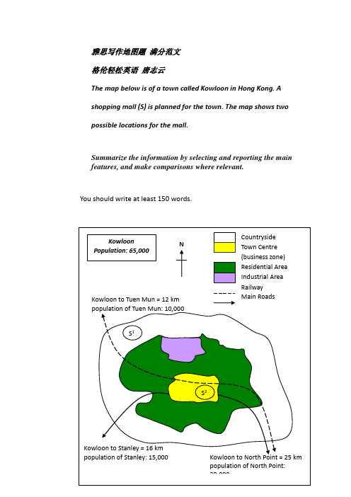
雅思写作地图题 满分范文 格伦轻松英语 唐志云The map below is of a town called Kowloon in Hong Kong. A shopping mall (S) is planned for the town. The map shows two possible locations for the mall.Summarize the information by selecting and reporting the main features, and make comparisons where relevant.You should write at least 150 words.KowloonPopulation: 65,000NKowloon to Tuen Mun = 12 km population of Tuen Mun: 10,000S 2S 1Kowloon to Stanley = 16 km population of Stanley: 15,000Kowloon to North Point = 25 km population of North Point: 29,000Countryside Town Centre (business zone) Residential Area Industrial Area RailwayMain RoadsSample AnswerThe given site map indicates two proposed locations for a new shopping mall for a town called Kowloon, in which around 65,000 people reside [居住].The first potential location, S1, is outside the town. Since it is in the countryside, it is a bit off the railway line which connects Kowloon to Tuen Mun (12 km to the north-west) and to North Point (25 km to the south-east). Moreover, it does not look convenient to the 15,000 residents in Stanley due to the lack of direct public transport including main roads.In contrast, the suggested location, S2, is right in the town centre, or the business zone. Obviously, it is quite accessible to local residents in the residential area that encloses the town centre and people working in the nearby industrial area to the north. In addition, it can be easily accessed by main roads or by rail from all the surrounding towns mentioned above.Simply put, the central location and good accessibility of S2 suggest that it may be the better choice.(around 168 words)。


一个地图题的开头:The map about the development of the village sufficiently illustrates the way of progress of this area. In this map, we can find four main sectors and two main roads intersected with one railway and one motor way. It seems the overall development of this village has strong connection with the construction of roads.雅思小作文地图题词汇Part 1:表时间流程图和地图题中都可能涉及时间表达。
流程题中,使用较多的是过程时长的表述,而地图题的时间使用则体现为地理变迁的时间变化。
一般在方位选址图题中较少出现。
确切的时间指引,既增加文章的自然和连贯度,也能体现行文的精确性。
常见表示时间的词:in few hours几小时during the period of …在…期间after 10 days 10天后from…to 从…到…between …and 在…之间over the…year period在一个…年期间5 years before 5年前a decade earlier几十年前from that moment on从那时起after a while一会since自从since then自从finally最后over the subsequent …years近连续几年例句:The process lasts for up to 7 day s and the products are finally distributed to customers.Part 2:表空间空间表达地图题出现概率较高,但流程图也偶尔出现。

雅思小作文——地图题注意事项:●图上所有的信息都要包括,不能够忽略任何一个地点描述步骤:●步骤1:确定描述对象【一个一个逐一描述】●步骤2:确定方位。
两种可能:(1)图上的地理位置;(2)参照物的位置。
一般来说,图上的地理位置优于参照物的位置,因为前者更加清晰和直接。
有时候为了表达丰富,可以地理位置和参照物都一起描述。
●步骤3:选择动词。
如located, situated, sited, constructed, built, developed等例:《剑9》Test 1 task 1步骤1 步骤2 步骤31确定island 参照物是sea 动词是surround 句子:The island is surrounded by the sea.2确定beach 地理位置是西边动词是located句子:A beach is located on the western end of the island.3确定trees 地理位置是西边和东边动词是scattered 句子:Some trees are scattered in the western and eastern sides of the island.步骤1 步骤2 步骤31确定西边的accommodation units 地理位置是西边,参照物是trees动词是built句子:A number of accommodation units are built surrounding those trees in the western part of the island.2确定footpath 参照物是accommodationunits,还有beach动词是connect参考范文1:The map shows the changes in an island, which is now a tourist attraction.The island is surrounded by sea. While a beach is located on the western end of the island,Tourism has led to some significant changes. A number of accommodation units are built surrounding those trees in the western part of the island. These facilities are connected with the beach, a site now open to swimmers, by a circular footpath. Another cluster of accommodation facilities is sited in the middle of the island next to trees, also linked by a footpath.Between these two groups of accommodation units is a reception and a restaurant lying to the north. There is a vehicle track linking the restaurant and the reception with a T-shaped pier constructed on the southern end of the island, which is used for yachting.In summary, the island has changed to cater for the needs of tourists after the construction of these facilities, while the trees have been well preserved.参考范文——7分范文:The two maps show the same island while first one is before and the second one is after the construction for tourism.Looking first at the one before construction, we can see a huge island with a beach in the west. The total length of the island is approximately 250 meters.【第一幅图片描述较为简单】Moving on to the second map, we can see that there are lots of buildings on the island. There are two areas of accommodation. One is in the west bear the beach while the other one is in the center of the island. Between them, there is a restaurant in the north and a central reception block, which is surrounded by a vehicle track. This track also goes down to the pierwhere people can go sailing in the south area of the island. Furthermore, tourists can swim near the beach in the west. A footpath connecting the western accommodation units also leads to the beach.【逻辑清晰,表达明确,句式复杂多样,几乎无语法毛病】Overall, comparing the two maps, there are significant changes after this development. Not only lots of facilities are built on the island, but also the sea is used for activities. The new island has become a good place for tourism.【末段总结到位】地理位置常用词汇:地图变迁题常用词汇:。

雅思小作文地图题给分【篇一:雅思小作文地图题】雅思小作文题型多样,其中就包括地图题,本文将详细讲解雅思小作文地图题写作技巧。
评分标准?ta – task achievement 任务完成情况?cc – coherence and cohesion 意合与形合?lr – lexical resource 词汇资源?gra – grammatical range and accuracy 语法广度与精确度审题the map below shows the development of the village of ryemouth between 1995 and present.文章结构第一段第二段描述1995年的地图第三段拿现在的地图和95年的做对比第四段总结全文第一段this report compares how the village of ryemouth has developed and changed since the year of 1995.题目:the map below shows the development of the village of ryemouth between 1995 and present.第二段as is clearly described in the first picture, ryemouth was a coastal city which was divided into three parts by two roads. in the southern part, there was a fishing port on the sea, with a fish market located in the north and a coffee shop in the north-east. a block of shops was situated on the opposite side of the market?第三段in the second picture, the village changed a lot. the fishing port has been removed and the fish market is replaced by apartments. several restaurants also occupy the place of theshops on the roadside. moreover, a parking lot is newly built on the east of the hotel. in addition, ?第四段overall, based on the brief description above, it is clear that the general layout of the village does not change a lot, while some newly-built facilities and housing has ornamented the small village.writing task 1you should spend about 20 minutes on this task.the diagram below shows the development of the village of kelsby between 1780 and 2000.summarise the information by selecting and reporting the main features, and make comparisons where relevant.write at least 150 words.新东方樊黎明:a类雅思地图题写作攻略首先注意两个点:1. 时态:本文的时间是明确的,是三个过去的时间,因此全文应当使用一般过去时。

雅思写作小作文范文雅思写作地图题map 楼层改造今天我们雅思写作小作文范文的文章来研究下地图题。
题目中展示了某家画廊同一楼层在整修之前和整修之后的平面图。
在整体面积不变的情况下,永久展示区的面积明显增大,临时展示区彻底消失,添加了新的特别展示区,并且改变了入口的位置。
那么如何用英语描述这些改变呢?小编搜集了一篇相应的考官范文,以供大家参考。
雅思写作小作文题目The diagrams below are existing and proposed floor plans for the redevelopment of an art gallery.Summarise the information by selecting and reporting the main features, and make comparisons where relevant.雅思写作小作文范文The first picture shows the layout of an art gallery, and the second shows some proposed changes to the gallery space.第一张图片展示了一个画廊的布局,第二张图片展示了画廊空间一些建议的改变。
It is clear that significant changes will be made in terms of the use of floor space in the gallery. There will be a completely new entrance and more space for exhibitions.很明显,在如何使用画廊空间上有巨大的改变。
将会有一个崭新的入口,同时展览也会有更多的空间。
At present, visitors enter the gallery through doors which lead into a lobby. However, the plan is to move the entrance to the Parkinson Court side of the building, and visitors will walk straight into the exhibition area. In place of the lobby and office areas, which are shown on the existing plan, the new gallery plan shows an education area and a small storage area.现在,游客通过通向大厅的门来进入画廊。

【9分作文盛宴】考官华丽雅思小作文详解6:地图题Simon是英国曼彻斯特的前雅思考官,由于创办雅思考试学习网站而在全世界的考生中越来越有名气。
其网站上提供大量关于复习雅思的技巧以及颠覆性的建议,甚至还有不少Simon本人亲笔写的满分作文。
这些满分作文由于出自英国考官之手,非常地道,言简意赅,和中国考生惯用的千篇一律的模板作文相比,着实让人眼前一亮。
点课台的Phoebe老师深感有义务要让孩子们接触到真正可以提分的好作文,所以以后会频繁地帮大家整理并总结这些满分作文的精华,相信大家都可以扔掉模板,写出高分作文!今天要分析的题目是地图——Maps。
有的学生说,地图题型相对不常见,所以备考可以忽略。
针对这种想法,Simon是这样说的:While it’s true that graphs andcharts are the most common types of question, I think it would be very unwise not to prepare for diagrams and maps too. What happens if you get one of these questions in your test and you haven’t prepared for it?虽然不常见,但是如果平时不做任何准备,万一考到后果不堪设想。
其实地图题并没有大家想象地那么难,只要花时间仔细研究一下Simon的范文,大家都能写出一篇好作文。
请看今天的题目,就是下面这个地图:写作文之前,要先Plan your structure,Simon建议地图题依然沿用4段式:1. Introduction: what does the chart show?2. Overview / summary: what are the most noticeable features?3. Specific details: try to write 2 paragraphs.接下来说地图题最难的地方——如何准确读出图中所给信息,我们就先来分析一下,从这个地图上我们可写的信息有哪些,首先地图上为数不多的单词或数字不可遗漏,上方那句是说这张图展现了一个叫做Chorleywood的村庄在1868年到1994年之间的发展情况。

地图题地图题:公园的过去和现在The two maps below give information of a village park between 10 years ago and now.范文:The two maps show the changes of a village park between 2004 and 2014 after some construction.In 2004, the entrance of the park faced to the northwestern. A large football pitch was sited in the middle of the park with other facilities around. Two tennis courts could be seen to the north. To the west of the pitch was located a car park, while to the east side was a children play area. A small pound and an area of woods were situated to the south.Now, circled by a cycle path, the village shows several changes except the central football pitch. Two tennis courts and one children play area have been added to the previous ones and the parking area has been extended to be able to hold another 50 cars. On the contrary, the woods have been cleared and give way to a cafe and a toilet. Besides, the original small pound has been converted to a boating lake.To conclude, the layout of the village has been rearranged in the decade, and consequently more leisure activities can be participated in the park.地图题:城市布局变迁The two maps show the changes of a city from 1960 to now.范文:The two maps show the development of a city from 1960 to the present.In 1960, the city was mainly based on the harbour and freight ships were moored in the northeast dock. To the east of the harbour was a business area, which was connected with the harbor and a stadium on the southern side of the river by trams. Moreover, two residential blocks were constructed at both the northern and southern ends of the city.Several major changes to the city have been observed since then. In 2014, the residential area in the north has given way to an extended business area of the one in the east. The previous dock has been occupied by some newly built restaurants and bars. The original intersecting tram frame has been simplified to a single line. Some sports facilities have been constructed between the southern residential area and the stadium, which is now also linked with the old business area by a footbridge over the river.To summarise, the landscape of the city has been rearranged, with more business replacing industry around the bay.地图题:学院布局变化The map below gives information about a college at present and its future view in 2015 after reconstruction.范文:The two figures demonstrate the estimated changes of a college between 2014 and 2015. At present, a garden lies in the northern part of the college and five car parks are located in the west. Both of them are linked to the school building by a footpath, while its entrance is in front of the garden. Inside the building, a lunch area and two classrooms lie in the western side, while one more classroom, a reception and a library are in the eastern part. For the southern edge, there is a toilet in the middle, and a bus stop on the southwestern corner, accessed by a road.In 2015, several changes are expected to be witnessed. The garden and the footpath will be removed, since the teaching building will be extended. A new shop will be established in the building’s northwestern corner, and the library will be moved to the southwestern end. Between them, there will be the original lunch area and one classroom, while other four classrooms will be seen in the opposite side. The entrance will be rebuilt in the middle southern edge, adjacent to the bus stop, and the corridor behind it will be replaced by a reception.To summarize, more rooms and car parks will be constructed in the college during the period.地图题:消防设备布置The diagram shows the fire plan for the second floor of a student dorm building in a university. Summarise the information by selecting and reporting the main features and make comparison where relevant.范文:The map illustrates the escape routes in case of fire on the second floor of a university dormitory. There are one lift, two stairways and seven bedrooms on this rectangle shape floor, all with access to the corridor in the center.Once the building is on fire, the stairs on the south-west corner is convenient for the students living in the west part of the floor, specifically, Bedroom 1, 2 and 3 to escape through the corridor because Bedroom 1 and 2 are located in the northwest corner and Bedroom 3 is right opposite the stairway. When they rush out of the building, they can meet the others at the Meeting Point 1 outside the stairway.Another stairway which is sited at the north side of floor, with the lift at the west and Bedroom 7 the east, offers another escaping way in case of fire. Bedroom 4, and 6 are on the south side of the corridor but face to this stairway, and Bedroom 5 is at the east side of the floor, next to Bedroom 6, therefore it is also easy for the dwellers in these three rooms to rush out. Once they get out of the building, they would meet at the Meeting Point 2 near the stair room.When you are old and grey and full of sleep,And nodding by the fire, take down this book, And slowly read, and dream of the soft look Your eyes had once, and of their shadows deep; How many loved your moments of glad grace, And loved your beauty with love false or true, But one man loved the pilgrim soul in you,And loved the sorrows of your changing face; And bending down beside the glowing bars, Murmur, a little sadly, how love fledAnd paced upon the mountains overheadAnd hid his face amid a crowd of stars.The furthest distance in the worldIs not between life and deathBut when I stand in front of youYet you don't know thatI love you.The furthest distance in the worldIs not when I stand in front of youYet you can't see my loveBut when undoubtedly knowing the love from both Yet cannot be together.The furthest distance in the worldIs not being apart while being in loveBut when I plainly cannot resist the yearningYet pretending you have never been in my heart. The furthest distance in the worldIs not struggling against the tidesBut using one's indifferent heartTo dig an uncrossable riverFor the one who loves you.。
雅思小作文题型多样,其中就包括地图题,本文将详细讲解雅思小作文地图题写作技巧。
评分标准•TA – Task Achievement 任务完成情况•CC – Coherence and Cohesion 意合与形合•LR – Lexical Resource 词汇资源•GRA – Grammatical Range and Accuracy 语法广度与精确度审题The map below shows the development of the village of Ryemouth between 1995 and present.文章结构第一段交待写作目的第二段描述1995年的地图第三段拿现在的地图和95年的做对比第四段总结全文第一段This report compares how the village of Ryemouth has developed and changed since the year of 1995.题目:The map below shows the development of the village of Ryemouth between 1995 and present.第二段As is clearly described in the first picture, Ryemouth was a coastal city which was divided into three parts by two roads. In the southern part, there was a fishing port on the sea, with a fish market located in the north and a coffee shop in the north-east. A block of shops was situated on the opposite side of the market…第三段In the second picture, the village changed a lot. The fishing port has been removed and the fish market is replaced by apartments. Several restaurants also occupy the place of the shops on the roadside. Moreover, a parking lot is newly built on the east of the hotel. In addition, …第四段Overall, based on the brief description above, it is clear that the general layout of the village does not change a lot, while some newly-built facilities and housing has ornamented the small village.WRITING TASK 1You should spend about 20 minutes on this task.The diagram below shows the development of the village of Kelsby between 1780 and 2000.Summarise the information by selecting and reporting the main features, and make comparisons where relevant.Write at least 150 words.新东方樊黎明:A类雅思地图题写作攻略首先注意两个点:1. 时态:本文的时间是明确的,是三个过去的时间,因此全文应当使用一般过去时。
有些地图会有将来的规划,那么则应使用相应的一般将来时。
2. 顺序:该图属于动态的地图题,这种类型的地图题一律按照时间顺序来写。
在这道题中,也就是按照图的顺序依次来写,不要把元素拆开。
如果是静态的地图题(即不涉及时间变化的题型),则按照空间顺序来写。
下面我们一起来分析文章的写作。
第一段:引言段。
引言段就是把题目进行改写。
原文中的diagram,可以替换成three maps/ illustrations. 原文中的shows,可以改为illustrate/ demonstrate/ indicate等词。
宾语development,可以替换成changes,也可以改为宾语从句how the village of Kelsby developed/ changed. 题目中给出的时间比较模糊,可以具体化为in 1780, 1860 and 2000.【例文】The three maps illustrate how the village of Kelsby changed in 1780, 1860 and 2000.第二段:介绍1780年的情况。
1780年的情况只涉及到静态的数据,因此只需要用存在句即可表达,不涉及任何变化的单词。
但是,考生非常容易把这些元素全部用there be这个句型来表达,从而导致句式单一。
表示存在的句型除了there be之外,还有非常简单的have句型,还有lie/ be located/ be situated 这样的结构。
另外还有一种倒装句型,比如“桌子上面有一本书”,可以翻译为on the desk is a book.除此之外,要注意几个元素的顺序问题。
这里有四大元素:住宅区homes,树林woods,农场farms,还有一条河流river。
理论上只要按照一定的空间顺序(比如顺时针、逆时针,从左到右)都是可以的,但是要考虑家庭数量的变化是导致其它所有变化的根本原因,因此建议先写。
还有就是土地单位的表达,land是不可数名词,因此不能说a land,只能说a piece of land。
为了表达更加精确,可以用a plot of land(一小块),a stretch of(一长片),a large expanse of (一大片)。
另外还有注意方位词的表达。
地图题中常用的方位词有:in the east/ west/ south/ north of ... ; in the eastern/ western/ southern northern part of ...; 如果是在角落,可以用in the southwestern corner of ... ; 在河流的上/下游:at the lower/ upper reaches of the river; 在河岸:alongside the riverbank, 在河流的南端:at the southern end of the river.【例文】In 1780, Kelsby had only 100 homes. There was a large expanse of woods in the eastern part of the village and four plots of farmland in the centre. In the west was a river flowing from north to south.第三段:介绍1860年的变化。
这一年的变化并没有时间先后,因此还是按照空间顺序来进行。
图上多了一个元素,即道路和桥梁的修建。
需要特别注意的是,因为考虑到和上文的呼应,这两个元素一定要放在后面讲,而家庭数量的增加和农场、树林面积的减少应当先讲。
这个原则我们简称叫“先拆后建”原则、第二点是时间的表达问题。
上文中刚刚出现过in 1780,这里还是用in 1860的话,句式上就会出现重复。
因此可以按照动态图里面学过的表达方法,把年份用作主语,用saw/ witnessed这两个词把数据引出来。
第三点是“建”这个词的英文表达。
常见的词有build, construct(一般建筑物),erect(高大的建筑物),establish/ set up(无建筑的物体或抽象的机构),pave(道路的修建)。
另外,如果涉及到拆除,则需要记住demolish, pull down, knock down 这些单词。
需要重点指出的是,这些表示“建”和“拆”的词都应当使用被动语态,这一点和普通流程图是一致的。
【例文】The year 1860 saw a doubling of the number of homes, but the size of farmland and woods was halved. In the same year, a bridge was constructed over the river and a road was paved linking the river to the residences.第四段:介绍2000年的变化。
首先还是时间的表达,这里可以再换一种结构,比如140 years later/ After 140 years。
首先还是“先拆后建”,先说树林农场彻底消失,然后在交代新的元素:学校和操场。
要记住的是,道路是不需要交代方位的,只需要把起点和终点表达出来即可,用link A to B或者connect A with B这类词组连接。
因此,道路的描写应放到学校、操场的后面。
【例文】140 years later, the number of homes more than doubled to 500, but farms andwoods completely disappeared. In their places, several school buildings and sports facilities were constructed at the south-eastern corner of the village, which were connected with the residential areas in the north via a newly-build road. Some shops opened up along the river bank and a large stretch of wetland for birds was established at the southern end of the river.。